

- Usage in publication:
-
- Mount Catherine rhyolite
- Modifications:
-
- First used
- AAPG geologic province:
-
- Cascades province
Summary:
First use of the Mt. [Mount] Catherine rhyolite. [Age is Eocene?].
Source: GNU records (USGS DDS-6; Menlo GNULEX).
- Usage in publication:
-
- Mount Catherine rhyolite
- Modifications:
-
- Named
- Dominant lithology:
-
- Rhyolite
- Tuff
- Breccia
- AAPG geologic province:
-
- Cascades province
Summary:
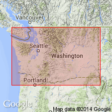
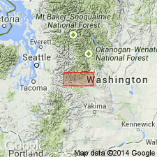
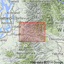
Mt. [Mount] Catherine rhyolite [forms horseshoe-shaped outcrop pattern, open toward the north, that extends northward about 5 miles from Mt. Catherine on the south, to Guye Peak at the northern end, in King and Kittitas Co., WA.] Type area in steep-walled canyon of Mill Creek, northeast of Mt. Catherine. Formerly included as part of the Guye formation (Smith and Calkins, 1906). Consists of light purple, light orange, and light blue-gray tuff and breccia most of which contains small, clear quartz phenocrysts. Thickness not given. Unconformably overlies Guye formation; unconformably overlain by the Naches formation. Age is probably Eocene.
Source: GNU records (USGS DDS-6; Menlo GNULEX).
- Usage in publication:
-
- Mount Catherine Rhyolite Member*
- Modifications:
-
- Adopted
- Revised
- Geochronologic dating
- Areal extent
- AAPG geologic province:
-
- Cascades province
Summary:
Mount Catherine Rhyolite Member is reduced in rank from Mt. Catherine rhyolite (Foster, 1960) and is the second to lowest member of the Naches Formation. Unit is restricted to rhyolite on Mount Catherine and major rhyolite lenses west of Gole Creek and on Kendall and Guye Peaks. Other rhyolite masses in the vicinity may also be correlative. Two ages of 35.9 +/-1.5 Ma and 35.5 +/-1.4 Ma (fission-track; zircon) from Mount Catherine provide a minimum age (may have been reset by intrusion of Snoqualmie batholith. Age is considered to be middle and late Eocene.
Source: GNU records (USGS DDS-6; Menlo GNULEX).
- Usage in publication:
-
- Mount Catherine Rhyolite Member*
- Modifications:
-
- Areal extent
- AAPG geologic province:
-
- Cascades province
Summary:
Mount Catherine Rhyolite Member of the Naches Formation is geographically extended into the report area. Age is middle and late Eocene.
Source: GNU records (USGS DDS-6; Menlo GNULEX).
For more information, please contact Nancy Stamm, Geologic Names Committee Secretary.
Asterisk (*) indicates published by U.S. Geological Survey authors.
"No current usage" (†) implies that a name has been abandoned or has fallen into disuse. Former usage and, if known, replacement name given in parentheses ( ).
Slash (/) indicates name conflicts with nomenclatural guidelines (CSN, 1933; ACSN, 1961, 1970; NACSN, 1983, 2005, 2021). May be explained within brackets ([ ]).