

- Usage in publication:
-
- Montana Mine Formation*
- Modifications:
-
- Named
- Dominant lithology:
-
- Chert
- AAPG geologic province:
-
- Midcontinent region
Summary:
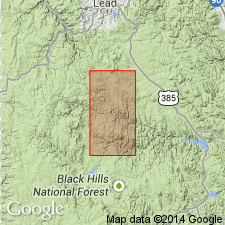
Named as the basal formation of the Flag Rock Group (rank raised) for Montana mine in sec 3, T2N, R3E, Lawrence Co, SD in the Midcontinent region, its type locality. Overlies Irish Gulch Slate (new). Overlain by Nahant Schist (new), or locally the Rapid Creek Greenstone (new), both of the Flag Rock Group. Composed of thick- to thin-bedded ferruginous chert and interlayers of silicate minerals, usually rosettes of grunerite, chlorite, mica, and garnet. Composition varies locally. Is similar lithologically to top formation of Flag Rock. Very generalized description of lithology. Areal extent beyond report boundaries not discussed. Formerly mapped as unnamed part of Flag Rock Formation. Is similar to youngest formation, Rochford Formation (new) of Flag Rock Group. Thickness not stated. Of middle Precambrian age. Geologic map.
Source: GNU records (USGS DDS-6; Denver GNULEX).

- Usage in publication:
-
- Montana Mine Formation*
- Modifications:
-
- Age modified
- AAPG geologic province:
-
- Midcontinent region
Summary:
Mapped with Early Proterozoic unit Xif (Pl. 1) in the Rochford area, Pennington Co, SD in the Midcontinent region. Geologic map.
Source: GNU records (USGS DDS-6; Denver GNULEX).
- Usage in publication:
-
- Montana Mine Formation*
- Modifications:
-
- Geochronologic dating
- AAPG geologic province:
-
- Midcontinent region
Summary:
A 1.88 +/-0.03 Ga U-Th-Pb zircon age obtained from iron-formation in the Montana Mine Formation at the Montana mine in the Rochford area, Pennington Co, SD in Midcontinent region.
Source: GNU records (USGS DDS-6; Denver GNULEX).
For more information, please contact Nancy Stamm, Geologic Names Committee Secretary.
Asterisk (*) indicates published by U.S. Geological Survey authors.
"No current usage" (†) implies that a name has been abandoned or has fallen into disuse. Former usage and, if known, replacement name given in parentheses ( ).
Slash (/) indicates name conflicts with nomenclatural guidelines (CSN, 1933; ACSN, 1961, 1970; NACSN, 1983, 2005, 2021). May be explained within brackets ([ ]).