

- Usage in publication:
-
- Miller Peak formation
- Modifications:
-
- Original reference
- Dominant lithology:
-
- Argillite
- Sandstone
- AAPG geologic province:
-
- Northern Rocky Mountain region
Summary:
Pg. 677-678, figs. 2, 3. Miller Peak formation. On Miller Peak consists of (descending): (1) purple massive to thin-bedded argillitic sandstone, some gray argillite, 235 feet; (2) red and purple sandy argillite, with some thin beds of green and gray argillite intercalated with argillitic sandstone, 1,440 feet; (3) pale green-gray argillitic sandstone 85 feet; (4) purple and green-gray sandy micaceous argillite weathering to rusty buff on joint faces, 590 feet; (5) purple sandy thin-bedded mud-cracked siliceous argillite, with some beds of finely micaceous argillite and gray sandy argillite, 550 feet. Underlies (unconformably?) Hellgate formation. Is Lower Camp Creek series of Walcott. Recognized in central western Montana, Missoula-Helena region. Age is pre-Cambrian (Belt).
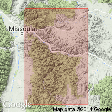
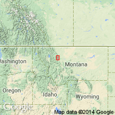
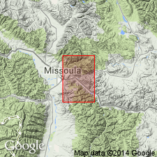
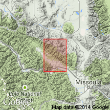
Type section: upper part of south flank of Miller Peak, [in center sec. 32, T. 12 N., R. 18 W., southeast corner Southeast Missoula 7.5-min quadrangle, Missoula Co., Lolo National Forest, western MT], where it rests conformably on Wallace (Siyeh) limestone.
Source: US geologic names lexicon (USGS Bull. 896, p. 1370).

- Usage in publication:
-
- Miller Peak formation
- Modifications:
-
- Revised
- AAPG geologic province:
-
- Northern Rocky Mountain region
Summary:
Pg. 1901-1903. Miller Peak formation of Missoula group. Basal formation of Missoula group. Comprises three members (ascending): Kintla, Roosville, and Mount Rowe (new). Underlies undifferentiated rocks of group; overlies Sheppard formation. Geographically extended into southwestern Alberta, Canada. [Age is Precambrian (Belt).]
Source: US geologic names lexicon (USGS Bull. 1200, p. 2504).
- Usage in publication:
-
- Miller Peak argillite*
- Modifications:
-
- Areal extent
- AAPG geologic province:
-
- Northern Rocky Mountain region
Summary:
Pg. 211-215. Miller Peak argillite. In Saypo quadrangle, conformably underlies Cayuse limestone (new). Thickness 1,000 feet; base cut out by Lewis overthrust. [Age is Precambrian (Belt).]
Source: US geologic names lexicon (USGS Bull. 1200, p. 2504).
- Usage in publication:
-
- Miller Peak formation*
- Modifications:
-
- Areal extent
- AAPG geologic province:
-
- Northern Rocky Mountain region
Summary:
Sheet 1. Miller Peak formation of Missoula group. Is basal formation of Missoula group. Underlies Hellgate formation. Age is Precambrian (Belt).
Source: Publication; US geologic names lexicon (USGS Bull. 1200, p. 2504).
- Usage in publication:
-
- Miller Peak argillite*
- Modifications:
-
- Revised
- Dominant lithology:
-
- Argillite
- Quartzite
- AAPG geologic province:
-
- Northern Rocky Mountain region
Summary:
Pg. F195 (fig.), F196-F199; USGS Misc. Inv. Ser. Map I-296, 1959. Miller Peak argillite of Missoula group. Stratigraphically expanded to include (ascending) Clapp and Deiss' Miller Peak formation, Hellgate formation (herein reduced to member status), and their lower member of McNamara formation (restricted). Consists of red and green silty argillite and argillaceous quartzite. Thickness about 6,000 feet. Underlies Bonner quartzite (new) of Missoula group; overlies Newland limestone of Piegan group. Age is Precambrian (Belt).
Source: Publication; US geologic names lexicon (USGS Bull. 1200, p. 2504).

- Usage in publication:
-
- Miller Peak Formation*
- Modifications:
-
- Redefined
- Areal extent
- AAPG geologic province:
-
- Northern Rocky Mountain region
Summary:
Miller Peak Formation of Missoula Group of Belt Supergroup. Name changed from Miller Peak Argillite/Formation to Miller Peak Formation only and geographically restricted to Missoula-St. Regis-Superior area. Replaces †Spruce Formation (now abandoned) in St. Regis-Superior area. Also †Kintla Argillite (now abandoned) included in part of Miller Peak. Age is Precambrian Y.
Source: Changes in stratigraphic nomenclature, 1972 (USGS Bull. 1394-A, p. A28-A29).

- Usage in publication:
-
- Miller Peak Argillite*
- Modifications:
-
- Areal extent
- AAPG geologic province:
-
- Northern Rocky Mountain region
Summary:
Pg. A8, A9 (Fig. 3). Miller Peak Argillite. Not recognized in Sun River Canyon area, northwestern Montana. Beds were miscorrelated with the Miller Peak Argillite of Missoula section by Deiss (1935, GSA Bull., v. 46, p. 95-124, Cambrian-Algonkian unconformity, western Montana). These beds are Spokane and Empire Formations of Ravalli Group of Belt Supergroup (citing McGill and Sommers, 1967, GSA Bull., v. 78, no. 3, p. 343-352, stratigraphy southern Lewis and Clark Range).
Source: Publication.
- Usage in publication:
-
- Miller Peak Formation*
- Modifications:
-
- Age modified
- AAPG geologic province:
-
- Northern Rocky Mountain region
Summary:
Is one of eleven formations of the Belt Supergroup mapped in report area. Age changed from Precambrian to Precambrian Y, the age term used for rocks that range in age from 1,600 to 800 m.y. old. No complete section present in quad; about 3,800 ft present. Mapped at east-central and south edges of map in Sanders and Missoula Cos, MT in the Northern Rocky Mountain region. Overlies Helena Formation of Belt; underlies Bonner Quartzite of Belt gradationally.
Source: GNU records (USGS DDS-6; Denver GNULEX).
For more information, please contact Nancy Stamm, Geologic Names Committee Secretary.
Asterisk (*) indicates published by U.S. Geological Survey authors.
"No current usage" (†) implies that a name has been abandoned or has fallen into disuse. Former usage and, if known, replacement name given in parentheses ( ).
Slash (/) indicates name conflicts with nomenclatural guidelines (CSN, 1933; ACSN, 1961, 1970; NACSN, 1983, 2005, 2021). May be explained within brackets ([ ]).