

- Usage in publication:
-
- Mill River conglomerate
- Modifications:
-
- Original reference
- AAPG geologic province:
-
- New England province
Summary:
Pg. 266-268. Mill River conglomerate. New name, here proposed by writer, after consultation with Dr. Keith, for the conglomeratic limestone which overlies the Middle Cambrian PARADOXIDES beds (St. Albans shale) and underlies Highgate shale (Upper Cambrian). Its fauna has not been carefully studied but it is believed to be Upper Cambrian.
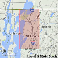
Named from Mill River, just east of which the formation is exposed about 2 mi southwest of St. Albans, 0.25 mi south of road running west from western foot of St. Albans Hill, [St. Albans 15-min quadrangle], Franklin Co., northwestern VT.
Source: US geologic names lexicon (USGS Bull. 896, p. 1373).
- Usage in publication:
-
- Mill River conglomerate
- Modifications:
-
- Biostratigraphic dating
- AAPG geologic province:
-
- New England province
Summary:
Pg. 374. Mill River conglomerate. Reported an abundant Upper Cambrian fauna from some limestone layers in Mill River conglomerate, and stated that it rests unconformably on St. Albans conglomerate.
Source: US geologic names lexicon (USGS Bull. 896, p. 1373).
- Usage in publication:
-
- Mill River conglomerate
- Modifications:
-
- Age modified
Summary:
Pg. 359, 368, 370-371. Mill River conglomerate. Reported re-worked St. Albans (Middle Cambrian) and Lower Cambrian fossils in this conglomerate, which he called a basal conglomerate, assigned it to base of Upper Cambrian, correlated it with typical Milton dolomite, and introduced new name Rugg Brook dolomite conglomerate for the so-called Milton dolomite of Keith, which underlies St. Albans slate and unconformably overlies Parker slate. Thickness of his Rugg Brook conglomerate 0 to 15 feet.
Source: US geologic names lexicon (USGS Bull. 896, p. 1373).
For more information, please contact Nancy Stamm, Geologic Names Committee Secretary.
Asterisk (*) indicates published by U.S. Geological Survey authors.
"No current usage" (†) implies that a name has been abandoned or has fallen into disuse. Former usage and, if known, replacement name given in parentheses ( ).
Slash (/) indicates name conflicts with nomenclatural guidelines (CSN, 1933; ACSN, 1961, 1970; NACSN, 1983, 2005, 2021). May be explained within brackets ([ ]).