

- Usage in publication:
-
- Mier sandstone member
- Modifications:
-
- Original reference
- Dominant lithology:
-
- Sandstone
- AAPG geologic province:
-
- Gulf Coast basin
Summary:
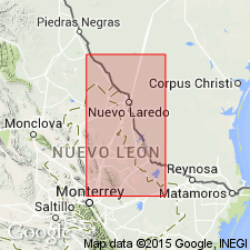
Pg. 1374, 1384. Mier sandstone member of Yegua formation. Basal 114 feet of Yegua formation of this region is characterized by a series of gray and red clay shales with a very heavy oyster bed (OSTREA GEORGIANA) beneath a prominent bench-forming massive soft gray sandstone, 125 feet thick, which is referred to in this report as Mier sandstone. A typical exposure of this sandstone can be seen in town of Ciudad Mier, Tamaulipas, northeastern Mexico. Immediately above Mier sandstone is a similar series of beds, 58 feet thick, with almost identical sequence of gray and red clay shales, overlain by a heavy bed of oysters (28 feet), and this in turn by another massive coarse-grained ridge-forming sandstone, 100 feet thick, which is referred to in this report as Alamo sandstone. A typical exposure of latter sandstone can be seen along east bank of Rio Alamo downstream from Ciudad Mier. Both of these sandstones have been traced more than 50 miles in Mexico and brought up to Rio Grande and traced into Texas as far as Arroyo Tigre, in Zapata County. The Alamo sandstone lies 132 feet below Alberca sandstone and 86 feet above Mier sandstone. Age is middle Eocene.
Source: US geologic names lexicon (USGS Bull. 896, p. 1367).
- Usage in publication:
-
- Mier sandstone tongue
- Modifications:
-
- Revised
- AAPG geologic province:
-
- Gulf Coast basin
Summary:
Pg. 264-265. Mier sandstone tongue of Yegua formation. Overlies La Perla shale member and underlies Jose shale member (both new). About 150 feet thick where it crosses into Starr County, southwestern Texas, from Mexico; thins northward and wedges out before latitude of Laredo is reached. [Age is middle Eocene.]
Source: US geologic names lexicon (USGS Bull. 1200, p. 2497).
For more information, please contact Nancy Stamm, Geologic Names Committee Secretary.
Asterisk (*) indicates published by U.S. Geological Survey authors.
"No current usage" (†) implies that a name has been abandoned or has fallen into disuse. Former usage and, if known, replacement name given in parentheses ( ).
Slash (/) indicates name conflicts with nomenclatural guidelines (CSN, 1933; ACSN, 1961, 1970; NACSN, 1983, 2005, 2021). May be explained within brackets ([ ]).