

- Usage in publication:
-
- Mesa Redondo member
- Modifications:
-
- Named
- Dominant lithology:
-
- Mudstone
- Siltstone
- Sandstone
- AAPG geologic province:
-
- Black Mesa basin
Summary:
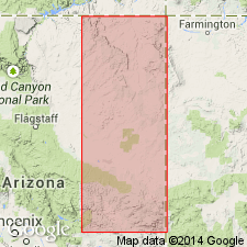
Named member of Upper Triassic Chinle formation for exposures at Mesa Redondo, Apache Co, AZ. Type section along north side Little Colorado River, 1-3 mi east of State Hwy 260, about 16 mi northwest of Concho, Apache Co, AZ, Black Mesa basin. Is 121 ft thick at type where unconformably overlies (erosional bleached zone with 1 ft of relief) Holbrook member of Moenkopi formation and underlies Petrified Forest Member of Chinle. At some localities, overlies and intertongues with Shinarump member of Chinle. At type, lower contact green-gray, very fine grained sandstone (Mesa Redondo) with thin-bedded gray-red mudstone and siltstone (Moenkopi). Upper contact gray-red sandstone (Mesa Redondo) transitional with varicolored mudstone and siltstone (Petrified Forest). Ranges 95-160 ft thick. Thickest section on Cedar Ridge 5 mi southeast of St. Johns, Apache Co. Divisible into: 1) lower ledge- and slope-forming unit of gray to red, very fine to medium grained sandstone, red-purple mudstone, brown sandy siltstone; 2) middle ledge-forming unit of cross-bedded red-purple conglomeratic, poorly sorted, firmly to weakly cemented sandstone; 3) upper slope-forming unit of gray-red mudstone, siltstone, and silty sandstone. Well exposed in valley between Holbrook (Navajo Co) and St. Johns, from Petrified Forest Monument to Concho, and between St. Johns south to Lyman Reservoir. Deposited in fluvial environment of torrential and quiet water type.
Source: GNU records (USGS DDS-6; Denver GNULEX).
- Usage in publication:
-
- Mesa Redondo Member*
- Modifications:
-
- Areal extent
- Overview
- AAPG geologic province:
-
- Black Mesa basin
Summary:
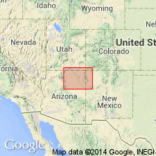
Is present as a member of the Upper Triassic Chinle Formation on the southern part of the Defiance Plateau and in the area south of the reservations east of Sunset Buttes, southern Navajo and Apache Cos, AZ in the Black Mesa basin. Consists of channel-type deposits having medium- to large-scale lenticular and wedge-shaped trough and planar cross-bedding. Pebbles less than 2 inches in diameter are concentrated in lower part of member. Areal extent map; mapped with Shinarump Member of Chinle. Block diagram. Overlies Shinarump; underlies Monitor Butte Member [on block diagram] or Petrified Forest Member [text] of Chinle. Overlap both Shinarump and Monitor Butte in age. Correlation chart.
Source: GNU records (USGS DDS-6; Denver GNULEX).
For more information, please contact Nancy Stamm, Geologic Names Committee Secretary.
Asterisk (*) indicates published by U.S. Geological Survey authors.
"No current usage" (†) implies that a name has been abandoned or has fallen into disuse. Former usage and, if known, replacement name given in parentheses ( ).
Slash (/) indicates name conflicts with nomenclatural guidelines (CSN, 1933; ACSN, 1961, 1970; NACSN, 1983, 2005, 2021). May be explained within brackets ([ ]).