

- Usage in publication:
-
- McIntosh formation*
- Modifications:
-
- Named
- Biostratigraphic dating
- Dominant lithology:
-
- Siltstone
- Claystone
- AAPG geologic province:
-
- Oregon-Washington Coast Ranges province
Summary:
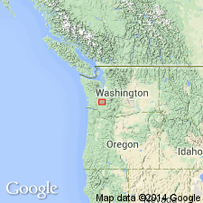
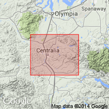
Named from exposures along south side of McIntosh Lake, southern Thurston Co, southwestern WA. Type area is central and southeastern parts of T16N R1W, extending into northern parts of secs.2 and 3 T15N R1W. [Extends over area a few tens of sq mi in southern Thurston and northern Lewis Cos.] Consists of sequence of dark-gray marine siltstone and claystone and interbedded arkosic and basaltic sandstone, 4000 to 4500 ft thick. Overlain disconformably by volcanic flows, pyroclastic, and sedimentary rocks; base not exposed. Foraminifera, identified by Weldon Rau, corroborated by paleofloral determination by Roland Brown, indicate formation is late middle Eocene.
Source: GNU records (USGS DDS-6; Menlo GNULEX).
- Usage in publication:
-
- McIntosh formation*
- Modifications:
-
- Age modified
- Biostratigraphic dating
- AAPG geologic province:
-
- Oregon-Washington Coast Ranges province
Summary:
Age extended to middle and late Eocene based on Foraminifera and paleofloral determinations by W.W. Rau and R.W. Brown, respectively.
Source: GNU records (USGS DDS-6; Menlo GNULEX).
For more information, please contact Nancy Stamm, Geologic Names Committee Secretary.
Asterisk (*) indicates published by U.S. Geological Survey authors.
"No current usage" (†) implies that a name has been abandoned or has fallen into disuse. Former usage and, if known, replacement name given in parentheses ( ).
Slash (/) indicates name conflicts with nomenclatural guidelines (CSN, 1933; ACSN, 1961, 1970; NACSN, 1983, 2005, 2021). May be explained within brackets ([ ]).