

- Usage in publication:
-
- Marca shale member
- Modifications:
-
- Principal reference
- Dominant lithology:
-
- Shale
- AAPG geologic province:
-
- San Joaquin basin
Summary:
Pg. 6 (fig. 2), 9, pls. 2, 3, 4, 5. See also 1941 [abs.], GSA Bull., v. 52, no. 12, pt. 2, p. 1954. Marca shale member of Moreno formation. White-weathering calcareous shale. Thickness 300 feet. Underlies Dos Palos shale member (new) of Moreno; overlies Tierra Loma shale member (new) of Moreno. Fossils (vertebrates at base, invertebrate megafossils, foraminifers). Age is Late Cretaceous. On the basis of this mapping it is concluded that Anderson and Pack (1915) show base of Moreno formation in [Ortegalito] Creek some 1,800 feet stratigraphically lower than their type Moreno in Moreno Gulch.
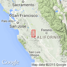
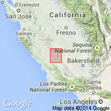
Type locality: Escarpado Canyon, Panoche Hills, 6 mi south of Moreno Gulch and 2 mi north of Panoche Creek, in secs. 7 and 8, T. 15 S., R. 12 E., [Chounet Ranch 7.5-min quadrangle], Fresno Co., southern CA. Named from Marca Canyon [about 5 mi north of type locality].
Source: Publication; US geologic names lexicon (USGS Bull. 1200, p. 2373-2374); GNU records (USGS DDS-6; Menlo GNULEX).
- Usage in publication:
-
- Marca Shale Member*
- Modifications:
-
- Adopted
- AAPG geologic province:
-
- San Joaquin basin
Summary:
Marca Shale Member of Payne (1941, 1951), lower member of the Moreno Shale, is adopted by the USGS. Age is Late Cretaceous.
Source: Changes in stratigraphic nomenclature, 1979 (USGS Bull. 1502-A, p. A45, A47); GNU records (USGS DDS-6; Menlo GNULEX).
- Usage in publication:
-
- Marca Shale Member*
- Modifications:
-
- Adopted
- Mapped
- Dominant lithology:
-
- Shale
- AAPG geologic province:
-
- San Joaquin basin
Summary:
Marca Shale Member of Moreno Formation is adopted by the USGS. (=Marca Shale Member of Payne, 1951.) Consists of tan to grayish-brown, laminated siliceous shale and diatomaceous shale containing white to light-brown calcareous concretions. Thickness up to about 92 m [about 302 feet].
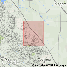
Type section: Escarpado Canyon, [6 mi south of Moreno Gulch and 2 mi north of Panoche Creek, Panoche Hills], in sec. 7, T. 15 S., R. 12 E., Chounet 7.5-min quadrangle, Fresno Co., southern CA (see Payne, 1951).
Source: Publication.
For more information, please contact Nancy Stamm, Geologic Names Committee Secretary.
Asterisk (*) indicates published by U.S. Geological Survey authors.
"No current usage" (†) implies that a name has been abandoned or has fallen into disuse. Former usage and, if known, replacement name given in parentheses ( ).
Slash (/) indicates name conflicts with nomenclatural guidelines (CSN, 1933; ACSN, 1961, 1970; NACSN, 1983, 2005, 2021). May be explained within brackets ([ ]).