

- Usage in publication:
-
- Manitoba group
- Modifications:
-
- Named
- Dominant lithology:
-
- Shale
- Limestone
- Dolomite
- Salt
- Anhydrite
- AAPG geologic province:
-
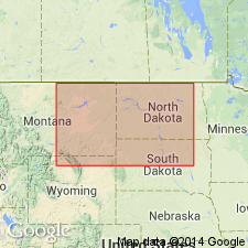
- Williston basin
Summary:
Name applied to carbonate and argillaceous rocks above the Prairie evaporite formation (new) of the Elk Point group (rank raised) and beneath the Saskatchewan group (new). No type locality designated. Probably named for the province. Occurs in SA and MB in CN, and in MT, ND, and SD in the US, in the Williston basin. Isopach map. Is thickest (800+ ft) in Manitoba. Cross sections. Divided into: Dawson Bay formation (new) at base; unnamed part; and in the SA part of the Williston, the Davidson evaporite (new) is recognized with the unnamed upper part. The Dawson Bay consists of shale, limestone, and dolomite. The Davidson consists of salt, anhydrite, and dolomite. Unnamed part [no detailed description] is mostly limestone. Middle-Upper Devonian boundary is in the group. Correlation chart. Correlated with part of the Maywood and part of the Jefferson formations of northwest MT.
Source: GNU records (USGS DDS-6; Denver GNULEX).
For more information, please contact Nancy Stamm, Geologic Names Committee Secretary.
Asterisk (*) indicates published by U.S. Geological Survey authors.
"No current usage" (†) implies that a name has been abandoned or has fallen into disuse. Former usage and, if known, replacement name given in parentheses ( ).
Slash (/) indicates name conflicts with nomenclatural guidelines (CSN, 1933; ACSN, 1961, 1970; NACSN, 1983, 2005, 2021). May be explained within brackets ([ ]).