

- Usage in publication:
-
- Little Jacks Tuff*
- Modifications:
-
- Named
- Dominant lithology:
-
- Tuff
- AAPG geologic province:
-
- Snake River basin
Summary:
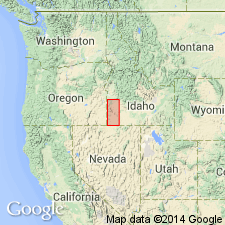
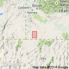
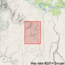
Named for Little Jacks Creek Canyon, Owyhee Co, ID in the Snake River basin. Type locality selected in SW1/4 sec 5, T9S, R3E. Is composed of gray, flow-layered and nonwelded rhyolite tuff. Has at least 4 cooling units at type locality. Is 15-100 m thick. Known only in Owyhee Co, ID. Source area inferred to be Owyhee plateau. Areal distribution map. Has K-Ar dates of 9.6 +/-2.0 and 10.0 +/-1.5 m.y. Is younger than tuff of Browns Creek and older than Banbury Basalt. Considered to be of Miocene age.
Source: GNU records (USGS DDS-6; Denver GNULEX).
- Usage in publication:
-
- Little Jacks Rhyolite*
- Modifications:
-
- Redescribed
- AAPG geologic province:
-
- Snake River basin
Summary:
Named changed from Little Jacks Tuff to Little Jacks Rhyolite to more adequately reflect lithologic character. Rocks are flow-banded devitrified lavas. Vitroclastic textures are recognizable in parts of some outcrops, most commonly at top and bottom parts of flow units, but these textures have been largely destroyed by annealing and shear deformation of glass shards during flow. Sigmoidal flow foliations, folds, and diapir structures are common in lava-like portions of flows. Attains maximum of 500 to 600 ft in study area. Has isotopic age of 10 to 9 Ma (Neill, 1975; Armstrong, 1980).
Source: GNU records (USGS DDS-6; Menlo GNULEX).
- Usage in publication:
-
- Little Jacks Tuff
- Modifications:
-
- Not used
Summary:
Not used in study area in central Owyhee Co, ID, Snake River basin. Ekren and others (1984) placed all rhyolitic rocks in mapped area within Little Jacks, which they considered to be a single, compound-cooling unit emplaced as a series of extremely hot pyroclastic flows. Little Jacks is actually a series of rhyolite lava flows and not a tuff. Within mapped area are eight separate rhyolite units that are informally named and mapped; these units are used in place of Little Jacks.
Source: GNU records (USGS DDS-6; Denver GNULEX).
For more information, please contact Nancy Stamm, Geologic Names Committee Secretary.
Asterisk (*) indicates published by U.S. Geological Survey authors.
"No current usage" (†) implies that a name has been abandoned or has fallen into disuse. Former usage and, if known, replacement name given in parentheses ( ).
Slash (/) indicates name conflicts with nomenclatural guidelines (CSN, 1933; ACSN, 1961, 1970; NACSN, 1983, 2005, 2021). May be explained within brackets ([ ]).