

- Usage in publication:
-
- Little Creek breccia
- Modifications:
-
- Areal extent
- Dominant lithology:
-
- Andesite
- Breccia
- AAPG geologic province:
-
- Great Basin province
Summary:
Pg. 18 (fig. 1), 40. Little Creek breccia member of Quichapa formation. Andesitic flows and breccia. Massive flow rock is dark red to dark purple and black; in addition to these colors, the brecciated rock is gray, olive green, and brown. Maximum thickness 1,200 feet. Overlies Bauers tuff member; underlies Harmony Hills tuff member. Age is Tertiary. Name credited to H.R. Blank, unpublished thesis [Univ. Washington PhD dissert. Bull Valley district, Washington Co., UT, 1959].
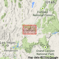
Not separately mapped. [Exposed west of Pine Valley Mountains], Washington Co., southwestern UT.
Source: US geologic names lexicon (USGS Bull. 1200, p. 2187); supplemental information from GNU records (USGS DDS-6; Denver GNULEX).
- Usage in publication:
-
- Little Creek breccia
- Modifications:
-
- Mapped
- AAPG geologic province:
-
- Great Basin province
Summary:
Little Creek breccia (informal) of Quichapa Group. Following Wiley (1963 Univ. Texas-Austin MS thesis, Jackson Mountain-Tobin Wash area), applies name Little Creek to strata corresponding in stratigraphic position and composition to Blank's (1959 Univ. Washington PhD dissert., Bull Valley district) Little Creek breccia but that is predominantly andesite flows rather than flow breccias. Is a vitrophyric andesite flow characterized by black glassy matrix and flow banding. Thickness up to 100 m; generally 30 m thick. Age is Miocene.
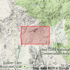
Notable exposures north of Grapevine Spring, in sec. 30, T. 39 S., R. 17 W., Gunlock 7.5-min quadrangle, Washington Co., southwestern UT.
Source: Publication.
For more information, please contact Nancy Stamm, Geologic Names Committee Secretary.
Asterisk (*) indicates published by U.S. Geological Survey authors.
"No current usage" (†) implies that a name has been abandoned or has fallen into disuse. Former usage and, if known, replacement name given in parentheses ( ).
Slash (/) indicates name conflicts with nomenclatural guidelines (CSN, 1933; ACSN, 1961, 1970; NACSN, 1983, 2005, 2021). May be explained within brackets ([ ]).