

- Usage in publication:
-
- Kougarok gravel*
- Modifications:
-
- Named
- Biostratigraphic dating
- Geochronologic dating
- Dominant lithology:
-
- Gravel
- Lignite
- AAPG geologic province:
-
- Seward Peninsula province
- Alaska West-Central region
Summary:
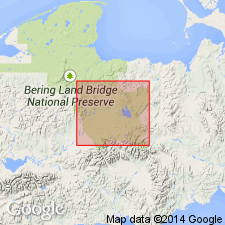
Named for good exposures along and near lower course of Kougarok River, Type locality designated in drainage basin of Quartz Creek, tributary of lower Kougarok River, Imuruk Lake area, Seward Peninsula, AK. Gravel sheet occupies belt 18 mi long and 1 to 4 mi wide extending along northwest margin of Kuzitrin Flats from Bunker Hill to valley of Noxapaga River. Consists of basal gravel member locally more than 187 ft thick, a thin middle member composed of peaty lignite, and upper gravel member, 3 to 60 ft thick. Overlies weathered bedrock in terrace on west side of Noxapaga River. Upper member rests directly on deeply weathered schist or on weathered lava flow of Kugruk volcanics (new) in terrace remnants between Grouse and Andesite Creeks. Age of upper member at type is more than 30,000 yr B.P. based on radio-carbon method (Meyer Rubin, written commun., 1955). Based on paleontololgical evidence upper member may have been deposited during early Pleistocene interglacial interval, and middle member is considered to be late Miocene or early Pliocene age. No fossils found in lower member which is probably middle or late Tertiary age based on stratigraphic relations.
Source: GNU records (USGS DDS-6; Menlo GNULEX).
- Usage in publication:
-
- Kougarok Gravel*
- Modifications:
-
- Biostratigraphic dating
- AAPG geologic province:
-
- Seward Peninsula province
- Alaska West-Central region
Summary:
Middle member of Kougarok Gravel contains rich pollen and wood flora. Comparisons with floras in southern AK suggest middle member of Kougarok is considerably older than early Pliocene age.
Source: GNU records (USGS DDS-6; Menlo GNULEX).
For more information, please contact Nancy Stamm, Geologic Names Committee Secretary.
Asterisk (*) indicates published by U.S. Geological Survey authors.
"No current usage" (†) implies that a name has been abandoned or has fallen into disuse. Former usage and, if known, replacement name given in parentheses ( ).
Slash (/) indicates name conflicts with nomenclatural guidelines (CSN, 1933; ACSN, 1961, 1970; NACSN, 1983, 2005, 2021). May be explained within brackets ([ ]).