

- Usage in publication:
-
- Kogosukruk tongue*
- Modifications:
-
- Named
- Dominant lithology:
-
- Clay
- Silt
- Shale
- Coal
- AAPG geologic province:
-
- Alaska Northern region
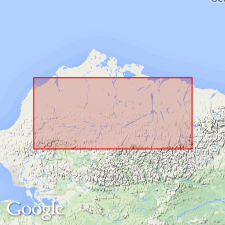
Summary:
Named as upper tongue (of 2) of Prince Creek formation of Colville group for Kogosukruk River, northern AK. Also exposed along Colville River from near its confluence with Anaktuvuk River to Ocean Point just north of 70th parallel. Consists largely of clay, silt, shale, bony coal, and bentonitic beds with minor sandstone and one conglomerate. Rare macrofossils consist of fresh-water and brackish-water pelecypods and gastropods. Thickness of 2340 ft includes Sentinel Hill member (new) of Schrader Bluff formation (new) of Colville group with which it intertongues. Overlies Tuluga member (new) of Schrader Bluff formation. Unconformably underlies thin mantle of Gubik formation of Pleistocene age. Age given for Kogosukruk tongue is Late Cretaceous.
Source: GNU records (USGS DDS-6; Menlo GNULEX).
- Usage in publication:
-
- Kogosukruk Tongue*
- Modifications:
-
- Overview
- AAPG geologic province:
-
- Alaska Northern region
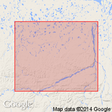
Summary:
Type section designated as exposures in bluffs on west bank of Colville River from near mouth of Anaktuvuk River to Ocean Point, northern AK. Distribution, detailed lithology with sketch maps of sandstones, stratigraphic correlation columns, lists of fossils and fossiliferous zones included in report. "Is at least partly equivalent in age to the Sentinel Hill Member [of Schrader Bluff Formation of Colville Group] which intertongues with the lower part and with base of the upper part and which is probably of Campanian or younger age." p.570.
Source: GNU records (USGS DDS-6; Menlo GNULEX).
- Usage in publication:
-
- Kogosukruk Tongue†
- Modifications:
-
- Abandoned
- AAPG geologic province:
-
- Alaska Northern region
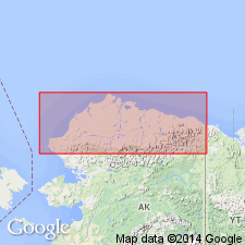
Summary:
Pg. 5 (fig. 4), 6-8 (table 1), 30. †Kogosukruk Tongue of Prince Creek Formation of †Colville Group. Abandoned. (†Colville also abandoned.) Rocks reassigned to Prince Creek Formation. [See Prince Creek.]
Source: Publication.
For more information, please contact Nancy Stamm, Geologic Names Committee Secretary.
Asterisk (*) indicates published by U.S. Geological Survey authors.
"No current usage" (†) implies that a name has been abandoned or has fallen into disuse. Former usage and, if known, replacement name given in parentheses ( ).
Slash (/) indicates name conflicts with nomenclatural guidelines (CSN, 1933; ACSN, 1961, 1970; NACSN, 1983, 2005, 2021). May be explained within brackets ([ ]).