

- Usage in publication:
-
- Kingston Canyon Tuff Member*
- Modifications:
-
- Named
- Dominant lithology:
-
- Tuff
- AAPG geologic province:
-
- Wasatch uplift
Summary:
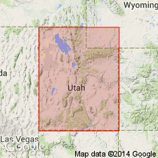
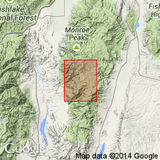
Named as the basal member of the Mount Dutton Formation in southern part of the Sevier Plateau. Type section designated on north side of Kingston Canyon in sec 16, T30S, R2 1/2 W, Piute Co, UT, on the Wasatch uplift. Conformably overlies and underlies breccia member of Mount Dutton. Has an average thickness of 12 m. Can be traced discontinuously over nearly 1,300 sq km of the Sevier Plateau. Consists of two petrologically similar cooling units of pale-purple plagioclase-biotite vitric welded tuff with a thin basal black vitrophyre. Correlation chart; fence diagram; measured sections. Of Miocene age.
Source: GNU records (USGS DDS-6; Denver GNULEX).
- Usage in publication:
-
- Kingston Canyon Tuff Member*
- Modifications:
-
- Age modified
- AAPG geologic province:
-
- Wasatch uplift
Summary:
Age of Antimony and Kingston Canyon Tuff Members of Mount Dutton Formation changed from Miocene to Oligocene. Age modification based not on new information but on use of 24 m.y. as the Miocene-Oligocene boundary. Kingston Canyon has a K-Ar age of 26-25 m.y. Mapped area is on Wasatch uplift.
Source: GNU records (USGS DDS-6; Denver GNULEX).
For more information, please contact Nancy Stamm, Geologic Names Committee Secretary.
Asterisk (*) indicates published by U.S. Geological Survey authors.
"No current usage" (†) implies that a name has been abandoned or has fallen into disuse. Former usage and, if known, replacement name given in parentheses ( ).
Slash (/) indicates name conflicts with nomenclatural guidelines (CSN, 1933; ACSN, 1961, 1970; NACSN, 1983, 2005, 2021). May be explained within brackets ([ ]).