

- Usage in publication:
-
- Kane Wash Formation
- Modifications:
-
- Named
- Dominant lithology:
-
- Basalt
- Tuff
- AAPG geologic province:
-
- Great Basin province
Summary:
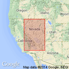
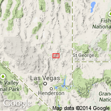
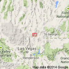
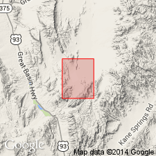
First published use of name for a unit that crops out extensively in the Meadow Valley Mountains and Delamar Range on both sides of Kane Springs Wash, Lincoln Co., NV. Distribution map shows formation extending across eastern NV (parts of Nye, Clark, Lincoln Cos.) between area north of Mercury and south of Caliente into a small area in adjacent Washington Co., UT, Great Basin province. Type section, at west end of Delamar Range approximately in sec. 5, T9S, R63E. Probably had an original extent of more than 6,000 sq mi, volume more than 750 sq mi, extending in a broad arc slightly convex southward from Bull Valley, NV, in the NTS, into UT. Is the youngest extensive ignimbrite formation in eastern NV. Rests disconformably on Hiko Tuff (new) or unconformably on Paleozoic rocks. Divisable into 6 members (numbered) that vary in mechanical composition and mineralogy; members also have several features in common --rare plagioclase, presence of quartz and sanidine in all; three have chatoyant sanidine. Basal unit at type is a 172 ft thick black, vesicular basalt with some white amygdules overlain by thin vitric ignimbrite, a 14-260 ft thick resistant unit and rhyolitic ignimbrite, lightly, to highly welded, brown, orange, pink, red to gray. Thought to correlate with Oak Spring group and the Alamo Spring formation of NV, and the Ox Valley tuff of UT. Cross sections. Nomenclature chart. Miocene age.
Source: GNU records (USGS DDS-6; Denver GNULEX).
- Usage in publication:
-
- Kane Wash Tuff*
- Modifications:
-
- Adopted
- Revised
- Geochronologic dating
- AAPG geologic province:
-
- Great Basin province
Summary:
Kane Wash Formation (Cook, 1965) is revised to Kane Wash Tuff, which reflects the composition of the [lithologically] revised unit. Cook's definition is essentially retained, with the exception that the basalt or other lavas and unrelated sedimentary rocks underlying or locally interbedded with the ash-flow tuff sheets are excluded from the formation. Age is Miocene based on K-Ar age of 14.0 +/-0.5 Ma [uncorrected].
Source: GNU records (USGS DDS-6; Menlo GNULEX).
- Usage in publication:
-
- Kane Wash Tuff
- Modifications:
-
- Revised
- Geochronologic dating
- AAPG geologic province:
-
- Great Basin province
Summary:
Kane Wash Tuff is divided into five units (ascending): member O, fayalite-bearing rhyolite ash-flow tuff (K-Ar ages 15.8 +/-0.2 and 15.5 +/-0.2 Ma); 2) member W, fayalite-bearing rhyolite ash-flow tuff (14.7 +/-0.2 Ma); 3) member V1, ash-flow tuff (14.2 +/-0.2 and 14.0 +/-0.2 Ma); 4) member V2, comendite ash-flow tuff (14.1 +/-0.2 Ma); 5) member V3, comendite ash-flow tuff (14.1 +/-0.2 Ma). Age is Miocene.
Source: GNU records (USGS DDS-6; Menlo GNULEX).
- Usage in publication:
-
- Kane Wash Tuff*
- Modifications:
-
- Revised
- Geochronologic dating
- AAPG geologic province:
-
- Great Basin province
Summary:
Kane Wash Tuff is revised and stratigraphically restricted. Includes only the uppermost petrographically-related ash-flow tuff members (V1 to V3) of Novak (1984). Here divided into the Grapevine Spring Member (= member V1)) and the Gregerson Basin Member (= members V2 and V3). Lowermost two members (W and O) of Novak (1984) are stratigraphically restricted from the Kane Wash; their rocks are reassigned to the (descending) Sunflower Mountain Tuff (new) and Delamar Lake Tuff (new). Restriction is based on the interpretation that members V1, V2, and V3 were erupted from the Kane Springs Wash caldera. The source of members W and O is unknown. Thickness ranges to approximately 170 m. Age is Miocene based on K-Ar ages of 14.0 +/-0.4 Ma (Grapevine Spring) and 14.2 +/-0.4 and 14.1 +/-0.4 Ma (Gregerson Basin).
Source: GNU records (USGS DDS-6; Menlo GNULEX).
For more information, please contact Nancy Stamm, Geologic Names Committee Secretary.
Asterisk (*) indicates published by U.S. Geological Survey authors.
"No current usage" (†) implies that a name has been abandoned or has fallen into disuse. Former usage and, if known, replacement name given in parentheses ( ).
Slash (/) indicates name conflicts with nomenclatural guidelines (CSN, 1933; ACSN, 1961, 1970; NACSN, 1983, 2005, 2021). May be explained within brackets ([ ]).