

- Usage in publication:
-
- Horseshoe Shale Member*
- Modifications:
-
- Named
- Reference
- Dominant lithology:
-
- Shale
- Siltstone
- Sandstone
- Limestone
- AAPG geologic province:
-
- Bighorn basin
- Powder River basin
Summary:
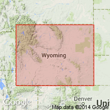
Named as middle member of Amsden Formation for Horseshoe Mountain, 7 mi southwest of Dayton, Sheridan Co, WY in Bighorn basin. Extends into Powder River basin. Type section SE1/4 sec 33, T57N, R87W, Amsden Creek, 4 mi west of Dayton. Reference section designated in lower Tensleep Canyon, at sta. 190, T47N, R88W, Washakie Co. Composed of red shale and siltstone in outcrop, and sandstone, limestone, and dolomite locally in subsurface. Color ranges from purple or maroon to brick red, and locally yellowish pinkish gray. Red to black ferruginous pisolites found in middle part; this "buckshot pellet" zone is widespread on both sides of Bighorn Mountains, east side Wind River Range, and southern Laramie Mountains. Is 100 ft thick at type, and 104 ft thick at reference section. Extends over WY from east flank of Bighorn Mountains to Gros Ventre Range, and from Granite Mountains to MT border. Greatest thickness is near Casper where more than 300 ft are present. At type section, disconformably overlies Madison Limestone (Mississippian); at reference section, overlies Darwin Sandstone Member of Amsden. Underlies Ranchester Limestone Member at both type and reference sections. Lower part is Chester, Late Mississippian; upper part is Morrow (fossils), Early Pennsylvanian. Is a stable shelf or platform deposit. Source area was distant. Correlates with lower parts of Morgan, Casper, and Hartville Formations.
Source: GNU records (USGS DDS-6; Denver GNULEX).
- Usage in publication:
-
- Horseshoe Shale Member*
- Modifications:
-
- Overview
- Reference
- Dominant lithology:
-
- Siltstone
- AAPG geologic province:
-
- Yellowstone province
- Powder River basin
- Wind River basin
- Bighorn basin
- Green River basin
Summary:
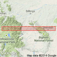
Reference section designated for Horseshoe Shale Member, middle member of Amsden Formation, in SW1/4 sec 34, T57N, R87W, Sheridan Co, WY in the Powder River basin. Horseshoe at that section 1) is 68.5 ft thick; 2) overlies Darwin Sandstone Member of Amsden; 3) underlies Ranchester Limestone Member of Amsden; 4) consists of grayish-red to red, fine-grained quartz siltstone, a few white, fine-grained quartz sandstones, and a covered interval that is probably red shale. Has the same distribution as the Darwin; is present in central WY from Rawlins north to MT border, and from central Natrona to Sheridan Cos west to Teton CO, including the Wind River, Powder River, Bighorn, and Greater Green River basins, and the Yellowstone province. Averages 75 ft thick; may be as much as 150 ft thick. Locally disconformably overlies Madison Limestone. Locally overlain by Moffat Trail Limestone Member (new) of Amsden. Fossils range from late Chesterian (Late Mississippian) to Morrowan (Early Pennsylvanian). Becomes younger eastward across WY shelf. Is an offshore marine deposit. Cross sections.
Source: GNU records (USGS DDS-6; Denver GNULEX).
For more information, please contact Nancy Stamm, Geologic Names Committee Secretary.
Asterisk (*) indicates published by U.S. Geological Survey authors.
"No current usage" (†) implies that a name has been abandoned or has fallen into disuse. Former usage and, if known, replacement name given in parentheses ( ).
Slash (/) indicates name conflicts with nomenclatural guidelines (CSN, 1933; ACSN, 1961, 1970; NACSN, 1983, 2005, 2021). May be explained within brackets ([ ]).