

- Usage in publication:
-
- Hebron gneiss
- Modifications:
-
- Named
- Dominant lithology:
-
- Gneiss
- Schist
- AAPG geologic province:
-
- New England province
Summary:
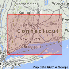
Named Hebron gneiss for Hebron, Tolland Co., CT. Unit shows great variety in composition and structures; it varies from a granitic gneiss to highly fissile schist. The Hebron forms an irregular band almost completely enclosing the Willimantic gneiss and it is intruded by granite. The Hebron grades into the Willimantic gneiss on one side and into Scotland and Brimfield schists on the other. The Willimantic gneiss is merely a more injected phase of the Hebron. The Bolton schist grades into the Hebron gneiss. The Hebron is probably of Carboniferous age.
Source: GNU records (USGS DDS-6; Reston GNULEX).
- Usage in publication:
-
- Hebron Formation*
- Modifications:
-
- Revised
- AAPG geologic province:
-
- New England province
Summary:
The Hebron Formation is here restricted to rocks in the area south and west of the Willimantic dome, south of the Wangumbaug Lake fault, and west of a fault in the Fitchville quad delineated by the Lebanon Gabbro. It includes the type area of the Hebron. Other rocks formerly mapped as Hebron are here assigned to the Oakdale, Dudley, and Southbridge Formations. It is separated from all other stratigraphic units by fault or intrusive contacts across which no stratigraphy can be correlated. Age is Late Proterozoic(?) based on correlation with part of the Paxton Group.
Source: GNU records (USGS DDS-6; Reston GNULEX).
For more information, please contact Nancy Stamm, Geologic Names Committee Secretary.
Asterisk (*) indicates published by U.S. Geological Survey authors.
"No current usage" (†) implies that a name has been abandoned or has fallen into disuse. Former usage and, if known, replacement name given in parentheses ( ).
Slash (/) indicates name conflicts with nomenclatural guidelines (CSN, 1933; ACSN, 1961, 1970; NACSN, 1983, 2005, 2021). May be explained within brackets ([ ]).