

- Usage in publication:
-
- Harmony formation*
- Modifications:
-
- Named
- AAPG geologic province:
-
- Great Basin province
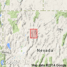
Summary:
Unit is named the Harmony Formation, for Harmony Canyon, Sonoma Range, NV. Consists of greenish-brown, micaceous grit, sandstone, and shale. Individual beds are lenticular. Grit consists mainly of bluish and transparent quartz grains, rounded to subangular. Amount of feldspar is variable. Some interbedded shale and small limestone lenses. Unit is unfossiliferous. Thickness is may exceed 5000 ft at type; elsewhere, generally more than 2000 ft thick. Age is Mississippian(?).
Source: GNU records (USGS DDS-6; Menlo GNULEX).
- Usage in publication:
-
- Harmony formation*
- Modifications:
-
- Areal extent
- AAPG geologic province:
-
- Great Basin province
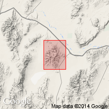
Summary:
Harmony Formation is geographically extended into the report area. Age is Mississippian(?). [Incorrectly shown as "new formation" on this map]
Source: GNU records (USGS DDS-6; Menlo GNULEX).
- Usage in publication:
-
- Harmony formation*
- Modifications:
-
- Age modified
- Biostratigraphic dating
- AAPG geologic province:
-
- Great Basin province
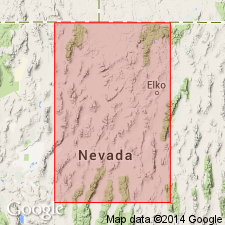
Summary:
Age of the Harmony Formation is Late Cambrian based on fossils (trilobites).
Source: GNU records (USGS DDS-6; Menlo GNULEX).
- Usage in publication:
-
- Harmony Formation*
- Modifications:
-
- Revised
- Areal extent
- AAPG geologic province:
-
- Great Basin province
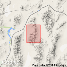
Summary:
Harmony Formation is geographically extended into report area (partially) at expense of the Inskip Formation.
Source: GNU records (USGS DDS-6; Menlo GNULEX).
For more information, please contact Nancy Stamm, Geologic Names Committee Secretary.
Asterisk (*) indicates published by U.S. Geological Survey authors.
"No current usage" (†) implies that a name has been abandoned or has fallen into disuse. Former usage and, if known, replacement name given in parentheses ( ).
Slash (/) indicates name conflicts with nomenclatural guidelines (CSN, 1933; ACSN, 1961, 1970; NACSN, 1983, 2005, 2021). May be explained within brackets ([ ]).