

- Usage in publication:
-
- Grande Ronde Basalt*
- Modifications:
-
- Principal reference
- Dominant lithology:
-
- Basalt
- AAPG geologic province:
-
- Eastern Columbia basin
Summary:
Pg. G2 (fig. 1), G4 (table 1), G6 (fig. 2), G10-11 (table 2), G16-G22, G23 (fig. 3), G24, G27, pl. 1. Grande Ronde Basalt, basal formation of the Yakima basalt subgroup [informal] of Columbia River Basalt Group. Name suggested by Taubeneck (1970, footnote, p. 75). Replaces informal lower Yakima basalt of Wright and others (1973); is essentially equivalent to Yakima Basalt of Waters (1961), except that his "late textural and mineralogic variant of the Yakima Basalt" (p. 600) is excluded.
Consists of aphyric to very sparsely phyric, fine-grained, tholeiitic basalt. Thickness 450 to 1000 m. Contains 4 informal magnetostratigraphic units of both reversed (R) and normal (N) polarities; called (ascending) R1, N1, R2, N2. Flows within the Grande Ronde range from 1 m to 100+ m thick; are defined as Grande Ronde chemical type ( = Yakima chemical type of Wright and others, 1973), and separated into High Mg and Low Mg chemical types. Flows of High Mg chemical type generally overlie flows of Low Mg (contact between the two is usually about 3 to 5 flows above the R2-N2 contact). Flows of Prineville chemical type (of Uppuluri, 1974) that are interbedded with flows of Grande Ronde chemical type (e.g., along Butte Creek, Tygh Ridge, and western Cascade Range) are assigned to Grande Ronde Basalt; flows of Prineville chemical type, near Prineville Dam, Crook County, north-central Oregon (see fig. 1, loc. 107), are not assigned to any formally named unit of the Columbia River Basalt Group (see p. G24).
Grande Ronde conformably overlies Imnaha Basalt or overlies and intertongues with Picture Gorge Basalt, both of Columbia River Basalt Group. Conformably and disconformably underlies Wanapum Basalt, or disconformably underlies Weissenfels Ridge Member (new) of Saddle Mountains Basalt (both in Yakima basalt subgroup of Columbia River Basalt Group). Top of Grande Ronde is generally well-defined by saprolite or arkosic to subarkosic siltstone and sandstone. In eastern part of Columbia Plateau, where saprolite or interbed is absent and overlying flows are aphyric and indistinguishable from Grande Ronde, contact is placed at the "titanium oxide discontinuity" (of Siems and others, 1974) [Authors note that although this boundary is not defined in accordance with NACSN code [1971], chemistry is a reliable tool for distinguishing units.] Is equivalent to most of Bond's (1963) "upper basalt" in the Clearwater embayment of Idaho. Areal extent map shows inferred original distribution in southern Washington, northern Oregon, and western Idaho (see pl. 1, fig. C). Age is early and middle Miocene, based on K-Ar dates from about 16.5 to 14.0 m.y. (citing Holmgren, 1970; Baksi and Watkins, 1973; Watkins and Baksi, 1974). (Grande Ronde Basalt adopted by the USGS.)
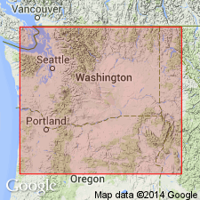
Type locality (see fig. 1, loc. 9 and pl. 1, fig. C): the prominent west-trending spur ridge, extending from NW/4 sec. 23 across N/3 sec. 22 to NE/4 sec. 21, T. 7 N., R. 46 E., Black Butte quadrangle, in the lower part of Grande Ronde River Valley, Asotin Co., extreme southeast WA (Eastern Columbia basin). Camp and others (1978) describe section at type in detail; total thickness about 830 m; consists of approx. 34 flows. Camp (1976), Price (1977), and Reidel (1978) give additional chemical and magnetic information.
Reference localities (see fig. 1, locs. 75, 76, 84, 105, 106, 108, 110, 111, 114): (1) in cliffs along Yakima River south of Ellensburg, in western part of Columbia Plateau, south-central WA (see Smith, 1901; Diery and McKee, 1969); (2) Crescent Bar, WA (see McDougall, 1976); (3) Divide Ridge and Windy Point, Tieton River area, WA (see Swanson, 1967); (4, 5) sections w/ minor faulting in Cow Canyon and Tygh Ridge, in southwest part of plateau, Wasco Co., northeast OR (see Waters, 1961; Nathan and Fruchter, 1974; Watkins and Baksi, 1974); (6, 7) sections structurally undisturbed at Sherars Bridge, along Deschutes River (in T. 3 S., R. 14 and 15 E.), and Beef Hollow, northeast OR (see Waters, 1961, R.D. Bentley and others, unpub. data, 1977); (8) along Butte Creek where interlayered contact of Grande Ronde and Picture Gorge is well exposed (see Cockerham and Bentley [abs.], 1973; Nathan and Fruchter, 1974); and (9) Ortley anticline, east of White Salmon, in the Columbia River Gorge, WA (see Hammond and others, 1977).
[Yakima basalt subgroup considered informal and should not be capitalized. "Subgroup" not recognized as a formal stratigraphic rank term (CSN, 1933; ACSN, 1961, 1970; NACSN, 1983, 2005, 2021). Columbia River Basalt Group adopted by the ID, OR, and WA Geol. Surveys, and the USGS.]
References cited:
Baksi, A.K., and Watkins, N.D., 1973, Science, v. 180, p. 493-496.
Bond, J.G., 1963, Idaho Bur. Mines and Geol. Pamphlet, no. 128, 83 p.
Camp, V.E., 1976, Washington State Univ. PhD dissert., 201 p.
Camp, V.E., and others, 1978, Rockwell Hanford Oper. Doc., RHO-BWI-LD-15, Richland, WA, 26 p.
Cockerham, R.S., and Bentley, R.D. [abs.], 1973, GSA Abs. with Prog., v. 5, no. 1, p. 23.
Diery, H.D., and McKee, Bates, 1969, Northwest Sci., v. 43, p. 47-64.
Hammond, P.E., and others, 1977, IN Brown, E.H., and Ellis, R.C., eds., Geol. excursions in Pacific Northwest, Western Washington Univ. Press, p. 127-169.
Holmgren, D.A., 1970, Washington Univ. MS thesis, 69 p.
McDougall, Ian, 1976, GSA Bull., v. 87, p. 777-792.
Nathan, Simon, and Fruchter, J.S., 1974, GSA Bull., v. 85, p. 63-76.
Price, S.M., 1977, US Atomic Energy Comm. Rept. ARH-SA-202, 29 p.
Reidel, S.P., 1978, Washington State Univ. PhD dissert., 415 p.
Smith, G.O., 1901, USGS Water-Supply Paper 55, 68 p.
Swanson, D.A., 1967, GSA Bull., v. 78, p. 1077-1110.
Taubeneck, W.H., 1970, IN Gilmour, E.H., and Stradling, Dale, eds., Proc. 2nd Columbia River Basalt Symp., Eastern Washington State Coll. Press, p. 73-96.
Uppuluri, V.R., 1974, GSA Bull., v. 85, p. 1315-1318.
Waters, A.C., 1961, Amer. Jour. Sci., v. 259, p. 583-611.
Watkins, N.D., and Baksi, A.K., 1974, Amer. Jour. Sci., v. 274, p. 148-189.
Wright, T.L., and others, 1973, GSA Bull., v. 84, p. 371-386.
Source: Publication; US geologic names lexicon (USGS Bull. 1564, p. 68); GNU records (USGS DDS-6; Menlo GNULEX); Changes in stratigraphic nomenclature, 1979 (USGS Bull. 1502-A, p. A31-A32).
- Usage in publication:
-
- Grande Ronde Basalt*
- Modifications:
-
- Revised
- AAPG geologic province:
-
- Eastern Columbia basin
Summary:
Grande Ronde Basalt of Columbia River Basalt Group. Subdivided into several informal units (descending): (1) Sentinel Bluffs, Slack Canyon, Field Springs [Fields Spring], Winter Water, Umtanum, Ortley, and Armstrong Canyon units of normal magnetic polarity, in N2 magnetostratigraphic unit; (2) Meyer Ridge, Grouse Creek, Wapshilla Ridge, and Mt. Horrible units of reverse magnetic polarity, in R2 magnetostratigraphic unit; (3) China Creek and Downey Gulch units of normal magnetic polarity, in N1 magnetostratigraphic unit; and (4) Center Creek, Rogersburg, Teepee Butte, and Buckhorn Springs units of reverse magnetic polarity, in R1 magnetostratigraphic unit. Lies above Imnaha Basalt and below Wanapum Basalt (both of Columbia River Basalt Group). Age is early to middle Miocene; isotopic ages from 16.5 Ma to 15.6 Ma.
Source: Publication.
For more information, please contact Nancy Stamm, Geologic Names Committee Secretary.
Asterisk (*) indicates published by U.S. Geological Survey authors.
"No current usage" (†) implies that a name has been abandoned or has fallen into disuse. Former usage and, if known, replacement name given in parentheses ( ).
Slash (/) indicates name conflicts with nomenclatural guidelines (CSN, 1933; ACSN, 1961, 1970; NACSN, 1983, 2005, 2021). May be explained within brackets ([ ]).