

- Usage in publication:
-
- Gale Hills Formation
- Modifications:
-
- Named
- Dominant lithology:
-
- Conglomerate
- Sand
- AAPG geologic province:
-
- Great Basin province
Summary:
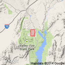
Gale Hills Formation is named for exposures in the Gale Hills, Clark Co, NV. Type section is located in T20S R65E [Callville Bay and Government Wash 7.5' quads]. Consists of three units (ascending): 1)basal conglomerate made of rounded pebbles and cobbles derived from several Paleozoic and Mesozoic formations, succeeded by layers of fine-grained sand, silt, and clay (similar to the Willow Tank Formation); 2) Sand derived from the Aztec Sandstone, abruptly grading into coarse bouldery deposits (resembles the Baseline Sandstone); 3) bouldery rubble derived from carbonate beds in [local] Paleozoic formations, grading into finer material, with local ash beds (resembles the Overton Fanglomerate). [Thickness is greater than 7500 ft, as shown on measured section.] Overlies the Aztec Sandstone; underlies the Horse Spring Formation. Age is Cretaceous(?) or Tertiary(?).
Source: GNU records (USGS DDS-6; Menlo GNULEX).
- Usage in publication:
-
- Gale Hills Formation
- Modifications:
-
- Not used
Summary:
Name not used. Rocks formerly assigned to it are reassigned to Baseline Sandstone, Horse Spring Formation, and to an informal unit called red sandstone unit. Stratigraphic diagram.
Source: GNU records (USGS DDS-6; Denver GNULEX).
For more information, please contact Nancy Stamm, Geologic Names Committee Secretary.
Asterisk (*) indicates published by U.S. Geological Survey authors.
"No current usage" (†) implies that a name has been abandoned or has fallen into disuse. Former usage and, if known, replacement name given in parentheses ( ).
Slash (/) indicates name conflicts with nomenclatural guidelines (CSN, 1933; ACSN, 1961, 1970; NACSN, 1983, 2005, 2021). May be explained within brackets ([ ]).