

- Usage in publication:
-
- Fort Rock Formation
- Modifications:
-
- Incidental mention
- AAPG geologic province:
-
- Southern Oregon basin
Summary:
Pg. 10. Incidental mention of Fort Rock formation in discussion of Fort Rock Park, south-central Oregon.
Source: US geologic names lexicon (USGS Bull. 1350, p. 268).
- Usage in publication:
-
- Fort Rock Formation*
- Modifications:
-
- Named
- Dominant lithology:
-
- Tuff
- Diatomite
- Agglomerate
- Lava
- AAPG geologic province:
-
- Southern Oregon basin
Summary:
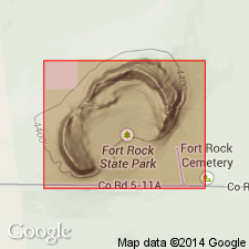
Pg. B5 (fig. 4), B7-B11, pl. 1. Fort Rock Formation. Formal proposal of name. Composed principally of four rock types. They are, in order of abundance, tuff, diatomite, basaltic agglomerate, and basaltic lava. Thickness 69.6 feet at type section. Unconformably overlies unnamed volcanic rocks of intermediate composition and Picture Rock Basalt (new). Unconformably overlain by Hayes Butte Basalt (new) and younger rocks. On basis of stratigraphic position, lithologic similarity to rocks in adjacent areas, and fossil evidence, the Fort Rock is tentatively assigned a middle and late Pliocene age. No single exposure typical of formation as a whole. Several reference localities named.
Type section: in NE/4 SW/4 sec. 33, T. 27 S., R. 17 E., on west side of Seven Mile Ridge, Lake Co., south-central OR. Named from Fort Rock, a remnant of an eruptive center of this unit, which rises above valley plains as mesalike butte in secs. 29 and 30, T. 25 S., R. 13 E. Characteristic exposures also at Table Rock Butte and Fandango Canyon-St. Patrick Mountain area.
Source: US geologic names lexicon (USGS Bull. 1350, p. 268).
For more information, please contact Nancy Stamm, Geologic Names Committee Secretary.
Asterisk (*) indicates published by U.S. Geological Survey authors.
"No current usage" (†) implies that a name has been abandoned or has fallen into disuse. Former usage and, if known, replacement name given in parentheses ( ).
Slash (/) indicates name conflicts with nomenclatural guidelines (CSN, 1933; ACSN, 1961, 1970; NACSN, 1983, 2005, 2021). May be explained within brackets ([ ]).