

- Usage in publication:
-
- Flattop Mountain suite
- Modifications:
-
- First used
- Dominant lithology:
-
- Rhyolite
- Rhyodacite
- AAPG geologic province:
-
- Great Basin province
Summary:
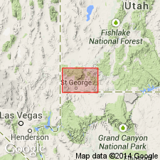
First published use of a name attributed to Blank (1959, an unpublished thesis). No type locality designated. Geographic feature Flattop Mountain is at the corner of T37S, Rs17 and 18W with T38S, Rs17 and 18W, Washington Co., UT in the Great Basin province. Consists of a "complex" of flows and small intrusive masses of eruptions from a restricted center Range from rhyolite to rhyodacite; from white to purple to black in color. Strong flow layering. Locally contacted. Phenocrysts sparse. Could exceed 1,000 ft in thickness. Mapped near Flattop Mountain where it is in contact with the Cove Mountain formation (first used) and as separate bodies to the south and east. Stratigraphic table. Tertiary age.
Source: GNU records (USGS DDS-6; Denver GNULEX).
- Usage in publication:
-
- Flattop Mountain Suite
- Modifications:
-
- Not used
Summary:
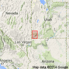
Not used. Replaced by informal rhyolite of Cow Hollow which is confined to Flat Top Mountain, west-southwest of Enterprise in southwest UT, Great Basin province. Unit had been informally called Cow Creek rhyolite of Flattop Mountain suite by Blank (1959) in unpublished PhD dissertation. New K-Ar dates on sanidine from rhyolite of Cow Hollow are 15 +-0.4 Ma and 14.3 +-0.4 Ma (Miocene); not known which of these discordant dates best approximates age of rhyolite of Cow Hollow.
Source: GNU records (USGS DDS-6; Denver GNULEX).
For more information, please contact Nancy Stamm, Geologic Names Committee Secretary.
Asterisk (*) indicates published by U.S. Geological Survey authors.
"No current usage" (†) implies that a name has been abandoned or has fallen into disuse. Former usage and, if known, replacement name given in parentheses ( ).
Slash (/) indicates name conflicts with nomenclatural guidelines (CSN, 1933; ACSN, 1961, 1970; NACSN, 1983, 2005, 2021). May be explained within brackets ([ ]).