

- Usage in publication:
-
- Fernie Formation
- Modifications:
-
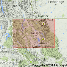
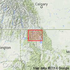
- Areal extent
- AAPG geologic province:
-
- Montana folded belt
Summary:
Geographically extended into small area south of the CN border on the northeast side of Whitefish Range, Flathead Co, MT in the Montana folded belt province. Consists of gray-black and brown-black shale, light-gray dolomite, sandstone, and siltstone with intercalated beds and discontinuous blocks of gray limestone. Poorly exposed, not resistant to erosion. Occurs as fault blocks. More than 500 ft thick. Is younger than Rocky Mountain Formation of Permian and Pennsylvanian age, and older than the Kootenai Formation of Cretaceous age. Assigned to the Jurassic. Geologic maps.
Source: GNU records (USGS DDS-6; Denver GNULEX).
- Usage in publication:
-
- Fernie Formation*
- Modifications:
-
- Areal extent
- AAPG geologic province:
-
- Montana folded belt
Summary:
An incomplete deformed section of Fernie mapped in a thrust plate immediately south of the CN border on the northeast Whitefish Range in Flathead Co, MT, Montana folded belt province. Lower part has black shale and gray limestone with belemnite fossils. Upper part is gray dolomitic sandstone interbedded with dark-gray siltstone and shale. Base not exposed. Minimum thickness is 500 ft. Unconformably overlies the Pennsylvanian and Permian Rocky Mountain Formation. In contact with Quaternary rocks. Assigned a Jurassic age.
Source: GNU records (USGS DDS-6; Denver GNULEX).
For more information, please contact Nancy Stamm, Geologic Names Committee Secretary.
Asterisk (*) indicates published by U.S. Geological Survey authors.
"No current usage" (†) implies that a name has been abandoned or has fallen into disuse. Former usage and, if known, replacement name given in parentheses ( ).
Slash (/) indicates name conflicts with nomenclatural guidelines (CSN, 1933; ACSN, 1961, 1970; NACSN, 1983, 2005, 2021). May be explained within brackets ([ ]).