

- Usage in publication:
-
- Farmington sandstone member*
- Modifications:
-
- Original reference
- Dominant lithology:
-
- Sandstone
- AAPG geologic province:
-
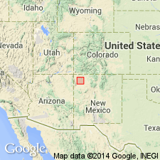
- San Juan basin
Summary:
Farmington sandstone member of Kirtland shale. Brown resistant sandstone, varying in thickness up to 455 feet, where it forms bluff on San Juan River. Present in southwestern Colorado and northwestern New Mexico. To south, it is gradually replaced with lenses of shale. Where thickest it lies 271 feet above base of Kirtland and 110 feet below top of Kirtland. Farther south it is 20 feet thick, lies 40 feet below top of the Kirtland and 830 feet above base of Kirtland, and still farther south it is represented only by isolated sandstone lenses in the Kirtland. Age is Late Cretaceous. Report includes geologic map, cross sections, history of nomenclature chart.
Source: US geologic names lexicon (USGS Bull. 896, p. 722); supplemental information from GNU records (USGS DDS-6; Denver GNULEX).

- Usage in publication:
-
- Farmington sandstone member*
- Modifications:
-
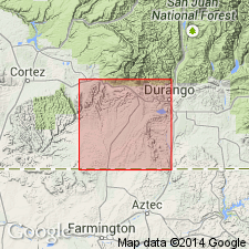
- [Areal extent]
- AAPG geologic province:
-
- San Juan basin
Summary:
Farmington sandstone member of Kirtland shale. Is 0 to 480 feet thick and of fluviatile origin. Age is Late Cretaceous.
Is well exposed near Farmington, San Juan County, New Mexico.
Source: US geologic names lexicon (USGS Bull. 896, p. 722).
- Usage in publication:
-
- Farmington sandstone member*
- Modifications:
-
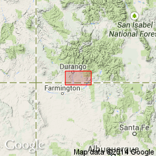
- Areal extent
- AAPG geologic province:
-
- San Juan basin
Summary:
Farmington sandstone member, middle member of Kirtland shale. Described in Red Mesa area, La Plata and Montezuma Counties, Colorado. Consists of thin- to massive-bedded lenses of sandstone separated by shale and sandy silty shale. Sandstone is pale olive, yellow, orange, fine- to medium-grained quartz with abundant feldspar and mica. Thickness about 345 feet. Underlies and overlies unnamed shale members of the Kirtland. Age is Late Cretaceous. Report includes geologic map, columnar section.
Source: US geologic names lexicon (USGS Bull. 1200, p. 1325-1326); supplemental information from GNU records (USGS DDS-6; Denver GNULEX).
- Usage in publication:
-
- Farmington Sandstone Member*
- Modifications:
-
- Areal extent
- AAPG geologic province:
-
- San Juan basin
Summary:
Mapped as the middle member of the Upper Cretaceous Kirtland Shale on five cross sections in the subsurface of southern La Plata Co, CO and northern San Juan Co, NM in the San Juan basin. Intertongues with lower shale member of Kirtland. Upper member of Kirtland identified at several localities.
Source: GNU records (USGS DDS-6; Denver GNULEX).
For more information, please contact Nancy Stamm, Geologic Names Committee Secretary.
Asterisk (*) indicates published by U.S. Geological Survey authors.
"No current usage" (†) implies that a name has been abandoned or has fallen into disuse. Former usage and, if known, replacement name given in parentheses ( ).
Slash (/) indicates name conflicts with nomenclatural guidelines (CSN, 1933; ACSN, 1961, 1970; NACSN, 1983, 2005, 2021). May be explained within brackets ([ ]).