

- Usage in publication:
-
- Estill clay
- Modifications:
-
- Named
- Dominant lithology:
-
- Clay
- AAPG geologic province:
-
- Cincinnati arch
Summary:
Pg. 10, 59; also 1905, Kentucky Geol. Survey Bull., no. 6, p. 145. Estill clay. Clay, 65 to 120 feet thick, overlying Waco limestone and forming top member of Alger formation (of Niagaran age). Overlain unconformably by Devonian limestone. Recognized in east-central Kentucky. Age is Silurian (Niagaran).
[GNC remark, US geologic names lexicon, USGS Bull. 896, p. 702: In 1931 (Kentucky Geol. Survey, ser. 6, v. 36, p. 172, 173) Foerste assigned this clay to Clinton epoch.]
Source: US geologic names lexicon (USGS Bull. 896, p. 702).
- Usage in publication:
-
- Estill clay
- Modifications:
-
- Overview
- AAPG geologic province:
-
- Cincinnati arch
Summary:
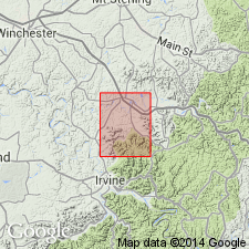
Pg. 132. Type exposure of Estill clay is northeast of Estill Springs, Estill County, north of Irvine, where it is 56 feet thick.
Source: US geologic names lexicon (USGS Bull. 896, p. 702).
- Usage in publication:
-
- Estill Shale
- Modifications:
-
- Revised
- AAPG geologic province:
-
- Cincinnati arch
Summary:
Estill clay [member] of Alger formation (Foerste, 1906) raised in rank to Estill Shale of Crab Orchard Group.
Source: GNU records (USGS DDS-6; Reston GNULEX).
- Usage in publication:
-
- Estill Shale Member*
- Modifications:
-
- Revised
- AAPG geologic province:
-
- Cincinnati arch
Summary:
Reassigned as Estill Shale Member of Crab Orchard Formation.
Source: GNU records (USGS DDS-6; Reston GNULEX).
- Usage in publication:
-
- Estill Shale Member*
- Estill Shale*
- Modifications:
-
- Revised
- AAPG geologic province:
-
- Cincinnati arch
Summary:
Pg. 4, 5 (fig. 3), 6 (fig. 4), 15-16, pl. 1. The Estill in its type area (south of, and within Bath County, Kentucky) is reassigned as uppermost member of Alger Shale of Crab Orchard Group, but in northern part of outcrop belt (north of Bath County, Kentucky) where underlying Dayton Dolomite Member is included in Drowning Creek Formation, the Estill is raised to rank of formation, as used by Rexroad and others (1965, Kentucky Geol. Survey Bulletin, no. 2, ser. 10). In latter area, Estill corresponds to map unit "upper part of Crab Orchard Formation" of most geologic maps produced during the USGS-KGS Mapping Program (1964-1978). Where entire unit is present, thickness ranges from 60 to 170 feet. Consists mainly of greenish-gray clay shale, with sparse reddish-brown zones about a foot thick especially near the base and particularly where Waco and Dayton are missing. A few brownish dolomite beds and lenses, generally less than 1 inch thick are commonly present, widely dispersed in the shale near the base of the unit, and less commonly higher. In Lewis County and adjacent Ohio, these sparse dolomite beds in the uppermost 30 feet of the Estill contain megafossils, mainly brachiopods, trilobites, and ostracodes, prompting Foerste (1931, p. 188-189) to split out a separate formation, the Ribolt clay, from the upper part of the Estill. Foerste's Ribolt was not used in the mapping program. Conformably underlies Bisher Dolomite in most of northern part of area and in a few localities near type locality; elsewhere is truncated by regional unconformity and underlies paraconformably Middle and Upper Devonian rocks. Report includes measured sections, columnar sections, correlation charts, x-ray analyses.
Source: Modified from GNU records (USGS DDS-6; Reston GNULEX).
For more information, please contact Nancy Stamm, Geologic Names Committee Secretary.
Asterisk (*) indicates published by U.S. Geological Survey authors.
"No current usage" (†) implies that a name has been abandoned or has fallen into disuse. Former usage and, if known, replacement name given in parentheses ( ).
Slash (/) indicates name conflicts with nomenclatural guidelines (CSN, 1933; ACSN, 1961, 1970; NACSN, 1983, 2005, 2021). May be explained within brackets ([ ]).