

- Usage in publication:
-
- Drowning Creek Formation*
- Modifications:
-
- Named
- Dominant lithology:
-
- Dolomite
- Limestone
- Shale
- Chert
- AAPG geologic province:
-
- Cincinnati arch
Summary:
A sequence of predominantly dolomite beds is here named the Drowning Creek Formation of the Crab Orchard Group. It is divided into 3 members in Bath Co., KY, and southward: the Brassfield, Plum Creek Shale, and Oldham Members, which are long established units. Brassfield is composed of dolomite or limestone beds with minor interbedded shale and chert nodules and lenses; 9 to 28 ft thick. The Plum Creek is greenish-gray, poorly fissile clay shale with beds and lenses of dolomite; about 5.5 ft thick. The Oldham is composed of interbedded gray, fossiliferous dolomite and greenish-gray, poorly fissile shale; 3 to 15 ft thick. Drowning Creek is divided into the Brassfield and Dayton Dolomite Members north of Bath Co., where the top of the Brassfield becomes difficult to locate, the Plum Creek and Oldham become indistinguishable, and the rock between the Oldham and the Dayton Dolomite becomes similar to the Oldham. The top of the Drowning Creek is, therefore, raised to the top of the Dayton Dolomite north of Bath Co. and called the Dayton Dolomite Member of Drowning Creek Formation, a gray, calcareous dolomite, generally unfossiliferous. Overlies the Preachersville Member of the Drakes Formation and underlies the Lulbegrud Shale Member of the Alger Shale at the type section, where it is 39 ft thick. Thickness ranges from 20 to 50 ft south of Bath Co., and 40 to 60 ft to the north. Age is Early and Middle Silurian (Albion to Niagaran).
Source: GNU records (USGS DDS-6; Reston GNULEX).
- Usage in publication:
-
- Drowning Creek Formation*
- Modifications:
-
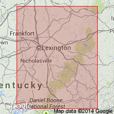
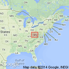
- Areal extent
- AAPG geologic province:
-
- Appalachian basin
Summary:
Geographically extended the Drowning Creek Formation into the subsurface of WV (OH-WV hinge zone) in section F-F'. Consists of (ascending) the Brassfield Member, "Clinton" sandstone of O'brien (1970), and Dayton Dolomite Member. Overlies the Juniata Formation.
Source: GNU records (USGS DDS-6; Reston GNULEX).
For more information, please contact Nancy Stamm, Geologic Names Committee Secretary.
Asterisk (*) indicates published by U.S. Geological Survey authors.
"No current usage" (†) implies that a name has been abandoned or has fallen into disuse. Former usage and, if known, replacement name given in parentheses ( ).
Slash (/) indicates name conflicts with nomenclatural guidelines (CSN, 1933; ACSN, 1961, 1970; NACSN, 1983, 2005, 2021). May be explained within brackets ([ ]).