

- Usage in publication:
-
- [Devils Pocket formation]
- Modifications:
-
- Overview
- AAPG geologic province:
-
- Central Montana uplift
Summary:
Pg. 143. Devils Pocket formation. Dolomite and limestone, partly sandy to siliceous, commonly red stained. Thickness ranges from 0 to 150 feet. Overlies Alaska Bench formation. Name credited to L.S. Gardner.
Source: US geologic names lexicon (USGS Bull. 1200, p. 1106).
- Usage in publication:
-
- Devils Pocket formation*
- Modifications:
-
- Principal reference
- Dominant lithology:
-
- Dolomite
- Limestone
- Sandstone
- AAPG geologic province:
-
- Central Montana uplift
Summary:
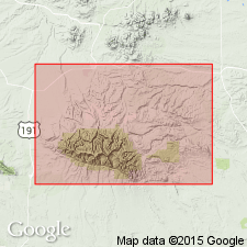
Pg. 332 (fig. 2), 334 (fig. 3), 336 (fig. 4), 347-348. Devils Pocket formation of Big Snowy group. Included in Big Snowy group. Conformably succeeds Alaska Bench limestone of Big Snowy group; overlain with probable unconformity by rocks of unknown late Paleozoic or post-Paleozoic age. Formation was removed by pre-Ellis erosion nearly everywhere in central Montana, and has been recognized in outcrop only by vicinity of Stonehouse Ranch, in sec. 32, T. 11 N., R. 21 E., where entire formation, 143 feet thick, is exposed, and at Durfee Creek dome where lower 71 feet remain. Fossiliferous. Age is Middle Pennsylvanian (Atokan). Type section designated.
Type section: in Road Canyon, in sec. 31, T. 11 N., R. 21 E., about 0.5 mi west of Stonehouse Ranch. Named from Devils Pocket, and anticlinal valley on a long anticlinal nose breached by erosion in southeastern Big Snowy Mountains (T. 10 N., R. 21 E.), where formation is 141 feet thick.
Source: US geologic names lexicon (USGS Bull. 1200, p. 1106); supplemental information from GNU records (USGS DDS-6; Denver GNULEX).
- Usage in publication:
-
- Devils Pocket Formation*
- Modifications:
-
- Revised
- AAPG geologic province:
-
- Sweetgrass arch
- Central Montana uplift
- Powder River basin
- Williston basin
Summary:
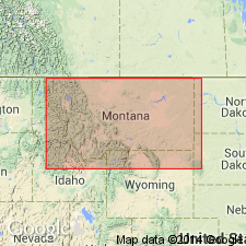
Removed from Big Snowy Group. Assigned as upper formation of Amsden Group (rank raised), above Alaska Bench Limestone (rank raised) and below Quadrant Formation. Bounded at top and at base by unconformities. Occurs in Central Montana uplift, Williston and Powder River basins, and Sweetgrass arch. Fossil chart. Correlation chart. Cross sections. Measured sections. Is of Middle, or Atoka and Des Moines age.
Source: GNU records (USGS DDS-6; Denver GNULEX).
For more information, please contact Nancy Stamm, Geologic Names Committee Secretary.
Asterisk (*) indicates published by U.S. Geological Survey authors.
"No current usage" (†) implies that a name has been abandoned or has fallen into disuse. Former usage and, if known, replacement name given in parentheses ( ).
Slash (/) indicates name conflicts with nomenclatural guidelines (CSN, 1933; ACSN, 1961, 1970; NACSN, 1983, 2005, 2021). May be explained within brackets ([ ]).