

- Usage in publication:
-
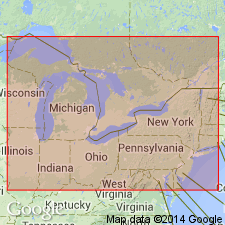
- Detroit River dolomite
- Modifications:
-
- Named
- Dominant lithology:
-
- Dolomite
- Limestone
- AAPG geologic province:
-
- Michigan basin
Summary:
Named the Detroit River dolomite in southeastern MI, western Ontario, CAN, and northern OH for the Detroit River. Includes (ascending) Flat Rock dolomite (40 to 150 feet thick), Anderdon limestone (40 to 50 feet thick), Amherstburg dolomite (20 feet thick), and Lucas dolomite (200 feet thick) members. Disconformably overlies Sylvania sandstone. The Detroit River is of Devonian age.
Source: GNU records (USGS DDS-6; Reston GNULEX).
- Usage in publication:
-
- Detroit River group
- Modifications:
-
- Revised
- AAPG geologic province:
-
- Michigan basin
Summary:
Revised the Detroit River to the Detroit River group. Includes the Sylvania sandstone at base. Maximum thickness is 1,000 feet in wells in central part of Southern Peninsula of MI; outcrop thickness commonly less than 200 feet. Wherever base of Sylvania is exposed, its contact with underlying rock is disconformable, and disconformity widens on leaving Michigan basin. In western Lake Erie region, the Sylvania lies on Bass Island[s] beds (Silurian). Beds overlying Detroit River group vary in age from place to place, indicating disconformity at top, but not as great as one at base. The Detroit River is of Middle Devonian age.
Source: GNU records (USGS DDS-6; Reston GNULEX).
For more information, please contact Nancy Stamm, Geologic Names Committee Secretary.
Asterisk (*) indicates published by U.S. Geological Survey authors.
"No current usage" (†) implies that a name has been abandoned or has fallen into disuse. Former usage and, if known, replacement name given in parentheses ( ).
Slash (/) indicates name conflicts with nomenclatural guidelines (CSN, 1933; ACSN, 1961, 1970; NACSN, 1983, 2005, 2021). May be explained within brackets ([ ]).