

- Usage in publication:
-
- Denny formation
- Modifications:
-
- Principal reference
- Dominant lithology:
-
- Marble
- Hornfel
- AAPG geologic province:
-
- Puget Sound province
- Eastern Columbia basin
Summary:
Pg. 111, pl. 1; 1957, Dissert. Abs., v. 17, no. 9, p. 1982. Denny formation. At type locality consists of medium- to coarse-crystalline marbles interbedded with fine-grained hornfels. Thickness not estimated; deformation and metamorphism that accompanied emplacement of Snoqualmie granodiorite has obscured structure. Rocks were included in Guye formation by Smith and Calkins (1906). Field relationships show Denny to be pre-Snoqualmie granodiorite and probably in fault contact with other rocks. Age is probably pre-Tertiary.
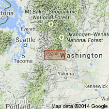
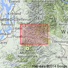
Type locality: Snoqualmie Mountain saddle, central Cascades Mountains. Confined to two small areas on Denny and Snoqualmie Mountains with total extent of less than 2 sq mi, [Snoqualmie National Forest, Snoqualmie Pass 7.5-min quadrangle, King Co., central WA].
Source: US geologic names lexicon (USGS Bull. 1200, p. 1091-1092).
- Usage in publication:
-
- Denny Formation
- Modifications:
-
- Not used
- AAPG geologic province:
-
- Puget Sound province
Summary:
Pg. 13. Denny Formation. The small bodies of marble, hornfels, and chert adjacent to Denny Mountain, called Denny Formation by Foster ([1960], p. 111), are included in "rocks of the eastern melange belt."
Source: Publication.
For more information, please contact Nancy Stamm, Geologic Names Committee Secretary.
Asterisk (*) indicates published by U.S. Geological Survey authors.
"No current usage" (†) implies that a name has been abandoned or has fallen into disuse. Former usage and, if known, replacement name given in parentheses ( ).
Slash (/) indicates name conflicts with nomenclatural guidelines (CSN, 1933; ACSN, 1961, 1970; NACSN, 1983, 2005, 2021). May be explained within brackets ([ ]).