

- Usage in publication:
-
- Dadina schists*
- Modifications:
-
- Named
- Dominant lithology:
-
- Schist
- Volcanics
- Limestone
- AAPG geologic province:
-
- Alaska Southern region
Summary:
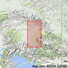
Occurs in valleys of Dadina and Chetaslina Rivers, tributaries of Copper River, southern AK. Shown on geologic map of central Copper River region. Northernmost exposure is along south side of tributary of Dadina that drains from flanks of Snider Peak where coarse quartz-biotite schist of unit has estimated height of 1500 ft above stream level. Across Dadina River rocks consist of (ascending): near base a succession of dark, bedded, crushed and altered lavas of andesitic type; higher are amphibolite schists, mica schists, and small bodies of gray marmorized limestones, all cut by quartz diorite dikes. Age tentatively regarded as pre-Silurian.
Source: GNU records (USGS DDS-6; Menlo GNULEX).
- Usage in publication:
-
- Dadina Schist*
- Modifications:
-
- Age modified
- AAPG geologic province:
-
- Alaska Southern region
Summary:
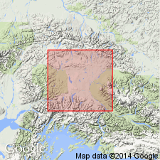
Listed as undivided with Strelna Formation (cropping out between Mount Drum and lower Chitina River). Both assigned to Carboniferous and possibly older(?) age. [no basis given for age determination]
Source: GNU records (USGS DDS-6; Menlo GNULEX).
For more information, please contact Nancy Stamm, Geologic Names Committee Secretary.
Asterisk (*) indicates published by U.S. Geological Survey authors.
"No current usage" (†) implies that a name has been abandoned or has fallen into disuse. Former usage and, if known, replacement name given in parentheses ( ).
Slash (/) indicates name conflicts with nomenclatural guidelines (CSN, 1933; ACSN, 1961, 1970; NACSN, 1983, 2005, 2021). May be explained within brackets ([ ]).