

- Usage in publication:
-
- Crooks Canyon Granodiorite*
- Modifications:
-
- Named
- Dominant lithology:
-
- Granodiorite
- AAPG geologic province:
-
- Southwestern Basin-and-Range region
Summary:
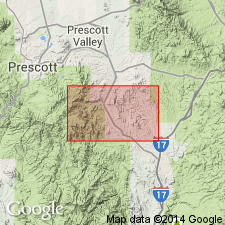
zzzzzNamed for Crooks Canyon about 2 mi south-southwest of Mount Union, Yavapai Co, AZ in the Southwestern Basin-and-Range region. Crops out in NE1/4 Mount Union quad on a high ridge south of Chaparral fault, as small bodies northwest of Chaparral fault, and as one small body near southeast corner of quad. Is resistant to erosion. Forms tan to gray bold outcrops. Is medium-grained, massive, foliated granodiorite with microcline, microperthite, sericitized albite and quartz interstitial to the feldspar. Ratio between potassium feldspar and plagioclase is variable. Small biotite crystals in aggregate concentrated in granulated feldspar and quartz suggestive of cataclasis. Accessory minerals include zircon and allanite. Chemical analyses. Geologic map. Age relation to Government Canyon Granodiorite unknown. A Precambrian plutonic rock.
Source: GNU records (USGS DDS-6; Denver GNULEX).
- Usage in publication:
-
- Crooks Canyon Granodiorite*
- Modifications:
-
- Overview
- Age modified
- AAPG geologic province:
-
- Southwestern Basin-and-Range region
Summary:
Assigned to suite one (of 4) in the Prescott area (Yavapai County, Arizona, Southwestern Basin-and-Range region). Suite one, consisting of pre-tectonic, equigranular, medium-grained biotite granodiorite and leucocratic granodiorite and granite plutons, includes the 1,750 +/-10 Ma Brady Butte Granodiorite, granodiorite of Minnehaha, granodiorite of Big Bug Creek, Crooks Canyon Granodiorite, granodiorite of Lane Mountain, and granite of Rich Hill. The plutons are moderately peraluminous, have very low magnetite concentrations, low to average strontium, and are concentrated in the central part of the area. Crooks Canyon cuts foliated granodiorite of Minnehaha. Is younger than granodiorite of Lane Mountain. Age is refined from Precambrian to Early Proterozoic. Report includes geochemical analyses.
Source: Modified from GNU records (USGS DDS-6; Denver GNULEX).
For more information, please contact Nancy Stamm, Geologic Names Committee Secretary.
Asterisk (*) indicates published by U.S. Geological Survey authors.
"No current usage" (†) implies that a name has been abandoned or has fallen into disuse. Former usage and, if known, replacement name given in parentheses ( ).
Slash (/) indicates name conflicts with nomenclatural guidelines (CSN, 1933; ACSN, 1961, 1970; NACSN, 1983, 2005, 2021). May be explained within brackets ([ ]).