

- Usage in publication:
-
- Corliss conglomerate*
- Modifications:
-
- Named
- Dominant lithology:
-
- Conglomerate
- AAPG geologic province:
-
- New England province
Summary:
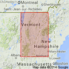
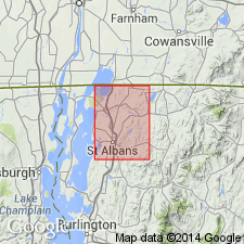
Named the Corliss conglomerate for Corliss, Franklin Co., northwestern VT. Unit rests on Highgate slate and forms a series of lenticular deposits between the Highgate and the overlying Georgia slate at intervals from Canada to their end, 5 miles south of St. Albans. Consists mainly of pebbles and boulders of various limestones, marbles, and dolomites, mostly limestone. The thin slabs of fossiliferous Upper Cambrian limestone derived from Mill River conglomerate (which underlies the Highgate) are numerous and conspicuous in the Corliss, which also contains fossiliferous pebbles of Early and Late Cambrian age. In Burlington region the Corliss overlies Williston limestone. Unit is very similar to the Mill River conglomerate but lies much higher in the section. The Corliss is of Early Ordovician age.
Source: GNU records (USGS DDS-6; Reston GNULEX).
- Usage in publication:
-
- Corliss conglomerate member
- Modifications:
-
- Revised
- AAPG geologic province:
-
- New England province
Summary:
Revised the Corliss to the Corliss conglomerate member of the Morses Line slate. Unit is considered of Middle(?) Ordovician age.
Source: GNU records (USGS DDS-6; Reston GNULEX).
For more information, please contact Nancy Stamm, Geologic Names Committee Secretary.
Asterisk (*) indicates published by U.S. Geological Survey authors.
"No current usage" (†) implies that a name has been abandoned or has fallen into disuse. Former usage and, if known, replacement name given in parentheses ( ).
Slash (/) indicates name conflicts with nomenclatural guidelines (CSN, 1933; ACSN, 1961, 1970; NACSN, 1983, 2005, 2021). May be explained within brackets ([ ]).