

- Usage in publication:
-
- Compeau Creek Gneiss*
- Modifications:
-
- Original reference
- Dominant lithology:
-
- Gneiss
- Tonalite
- Granodiorite
- Amphibolite
- AAPG geologic province:
-
- Lake Superior region
- Wisconsin arch
Summary:
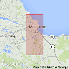
Pg. 18-27. Compeau Creek Gneiss. Present north and south of synclinorium, in Marquette and Sands 7.5-min quadrangles, Marquette County, northwestern Michigan. Formerly part of northern and southern complexes of Van Hise and Bayley, 1897 (USGS Monograph 28). Consists of foliated light-colored tonalite and granodiorite, dark chloritic, biotitic, and hornblendic varieties of these rocks, and amphibolite. Quartz monzonite and monzonitic rocks are not common; granite is rare. Color is mainly pink or salmon. Faint streaky layering is seen in places. Locally (in north half of Marquette quadrangle) carries septa of greenstone, interpreted as remnants of Mona Schist. [Thickness of Compeau Creek not stated.] Intrudes Lighthouse Point Member of Mona Schist. Metamorphosed to amphibolite facies. Age is early Precambrian. Bulk of Compeau Creek is considered pre-Animikie and is probably at least 2 billion years old (based on K-Ar ages of about 1,800 Ma for pegmatite intrusive into Animike rocks in Dickinson Co., MI, reported by James and others, 1961, USGS Prof. Paper 310).
Type locality: Compeau Creek, in northern part of Marquette 7.5-min quadrangle, Marquette Co., northwestern MI. Named from Compeau Creek.
Source: Publication; Changes in stratigraphic nomenclature, 1968 (USGS Bull. 1294-A, p. A5).
- Usage in publication:
-
- Compeau Creek Gneiss*
- Modifications:
-
- Overview
- Dominant lithology:
-
- Gneiss
- Amphibolite
- AAPG geologic province:
-
- Lake Superior region
Summary:
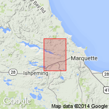
Is mapped as two units in Marquette Co, Upper Michigan Peninsula (Lake Superior region). Largely gneissic to massive granulitic rocks with small amounts of amphibolite, many masses too small to show at map scale. Granitic gneiss: massive to prominently foliated, light-colored quartz-feldspar rock; largely tonalite but more potassic phases also common; mostly equigranular but some irregular pegmatitic patches on rare pegmatite dikes; layering best shown by biotitic layers or schlieren and, in places, by concentrations of garnet grains; garnets typically red, about 0.5 cm diameter, and partly chloritized; plagioclase An20-25; microcline is microperthitic, mesoperthitic in some pegmatites; accessory zircon, calcite, apatite, magnetite, hematite, ilmenite, and sphene. Amphibolite: light- to dark-green plagioclase-amphibole rock; typically gneissic and commonly with strong preferred alignment of c-axes of hornblende; most is medium grained with maximum grain size about 1 mm; hornblende is pleochroic in shades of blue, green, yellow, but shows considerable variation in color between outcrops; plagioclase variable, up to about An60; biotite (light- to dark-brown pleochroism) is common and quartz is generally present in small amounts; accessory sphene, epidote, zircon, apatite, chlorite, calcite, hematite, magnetite, and ilmenite. Precambrian W.
Source: GNU records (USGS DDS-6; Denver GNULEX).
- Usage in publication:
-
- Compeau Creek Gneiss*
- Modifications:
-
- Overview
- Dominant lithology:
-
- Gneiss
- Granodiorite
- AAPG geologic province:
-
- Lake Superior region
Summary:
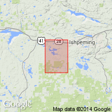
Is early Precambrian formation mapped in area of about 6.2 sq mi in northeast part of Negaunee quadrangle, Marquette Co, MI (Lake Superior region). Borders layered amphibolite of Lighthouse Point Member of Mona Schist (older early Precambrian). Map unit described as light-gray to light-pink foliated medium- to coarse-grained tonalitic gneiss; weathers reddish brown; local zones of intense silicification. Outcrops are massive; forms hills with steep slopes and rounded summits. Modes of typical gneiss: 26-28 percent quartz, 18-20 percent microcline, 44-50 percent plagioclase, 2-7 percent chlorite, and traces of apatite, sphene, epidote, and zircon. Chlorite is probably altered hornblende. Epidote, sphene, and apatite commonly adjacent to quartz. Quartz is granoblastic aggregates 1-2 mm wide and 5-10 mm long; external boundaries of aggregates adjacent to feldspar are smooth and sharp. Plagioclase is anhedral to euhedral, generally prismatic, as large as 1.4 x 1.6 mm; clouded by sericite and clay minerals; analyses suggest oligoclase. Clear, unaltered microcline occurs as discrete anhedral crystals and as highly irregular grains surrounding plagioclase and other minerals. Rock is compositionally granodiorite.
Source: GNU records (USGS DDS-6; Denver GNULEX).

- Usage in publication:
-
- Compeau Creek Gneiss*
- Modifications:
-
- Overview
- AAPG geologic province:
-
- Lake Superior region
Summary:
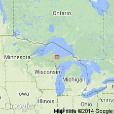
Is present in western upper MI in the Lake Superior region. Gneiss is dominantly tonalitic to granodioritic in composition and contains lenses and layers of amphibolite. Locally, along Southern complex of Van Hise and Bayley (1895), intrudes Bell Creek Gneiss. Correlation chart. Although locally affected by later anatexis, age is considered to be Late Archean.
Source: GNU records (USGS DDS-6; Denver GNULEX).
- Usage in publication:
-
- Compeau Creek Gneiss*
- Modifications:
-
- Not used
Summary:
An Archean crustal boundary (the Great Lakes tectonic zone) that separates an Archean greenstone-granite terrane on the north from an Archean gneiss terrane on the south, is recognized in outcrop in the Marquette area, MI (Lake Superior region). The boundary, marked by a 2.5-km-wide mylonite zone, is interpreted as a continent-continent collision zone. The area was previously mapped by Gair and Thaden (1968), who "applied the name 'Compeau Creek Gneiss' to both the foliated granitoid rocks of the Archean greenstone-granite terrane and the layered gneisses and massive intrusions of the gneiss terrane, and subsequent investigators extended this terminology to the western parts of the southern complex (Cannon and Simmons, 1973). It is inappropriate, however, to apply this name to the rocks in both Archean terranes because the two terranes consist of distinctive rock types of different origins. Accordingly, in this report informal lithologic names are used to describe the crystalline rocks in the two diverse terranes."
Source: GNU records (USGS DDS-6; Denver GNULEX).
For more information, please contact Nancy Stamm, Geologic Names Committee Secretary.
Asterisk (*) indicates published by U.S. Geological Survey authors.
"No current usage" (†) implies that a name has been abandoned or has fallen into disuse. Former usage and, if known, replacement name given in parentheses ( ).
Slash (/) indicates name conflicts with nomenclatural guidelines (CSN, 1933; ACSN, 1961, 1970; NACSN, 1983, 2005, 2021). May be explained within brackets ([ ]).