

- Usage in publication:
-
- Cholla Canyon tongue*
- Modifications:
-
- Original reference
- Dominant lithology:
-
- Sandstone
- AAPG geologic province:
-
- San Juan basin
Summary:
Sheet 1. Cholla Canyon tongue of Cliff House sandstone of Mesaverde Group. Described as small tongue of Cliff House sandstone in Menefee formation. As a result of this tonguing, approximately 60 feet of beds at top of Menefee formation are replaced northeastward by Cliff House sandstone. Contacts are sharp. Age is Late Cretaceous.
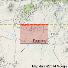
Exposed within southeasterly trending band about 0.5 mi wide and about 3 mi southwest of edge of Barker Dome tongue. These exposures are along southwestern flanks of Barker and Southern Ute Domes and are especially well developed at the head of Cholla Canyon, in secs. 9, 10, and 15, T. 31 N., R. 14 W., San Juan Co., northwestern NM.
Source: US geologic names lexicon (USGS Bull. 1200, p. 789).
For more information, please contact Nancy Stamm, Geologic Names Committee Secretary.
Asterisk (*) indicates published by U.S. Geological Survey authors.
"No current usage" (†) implies that a name has been abandoned or has fallen into disuse. Former usage and, if known, replacement name given in parentheses ( ).
Slash (/) indicates name conflicts with nomenclatural guidelines (CSN, 1933; ACSN, 1961, 1970; NACSN, 1983, 2005, 2021). May be explained within brackets ([ ]).