

- Usage in publication:
-
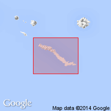
- Chitka Point formation*
- Modifications:
-
- Named
- Dominant lithology:
-
- Andesite
- AAPG geologic province:
-
- Aleutian Islands province
- Alaska Southwestern region
Summary:
Type locality designated at Chitka Point, Amchitka Island, Aleutian Islands, southwestern AK. Underlies most of the mountains in west half of island. Consists of lava flows and flow breccia of porphyritic andesite interbedded with marine conglomerate. Probably exceeds 1000 ft in thickness. Unconformably overlies Amchitka formation (new). Dikes of porphyritic rock similar to lava of Chitka Point formation cut Banjo Point (new) and Amchitka formations. South of Chitka Point, unit underlies gravel deposit of hornblende andesite. Age is estimated to be middle or late Tertiary based on stratigraphic relations. "... no evidence to rule out possibility that it might be early Quaternary." p.539.
Source: GNU records (USGS DDS-6; Menlo GNULEX).
- Usage in publication:
-
- Chitka Point Formation*
- Modifications:
-
- Age modified
- Geochronologic dating
- AAPG geologic province:
-
- Aleutian Islands province
- Alaska Southwestern region
Summary:
Age is middle Miocene based on K-Ar ages of 14.1 +/-1.1 to 12.4 +/-1.1 Ma from samples from Chitka Point Formation (Carr and others [1970], 1971).
Source: GNU records (USGS DDS-6; Menlo GNULEX).
For more information, please contact Nancy Stamm, Geologic Names Committee Secretary.
Asterisk (*) indicates published by U.S. Geological Survey authors.
"No current usage" (†) implies that a name has been abandoned or has fallen into disuse. Former usage and, if known, replacement name given in parentheses ( ).
Slash (/) indicates name conflicts with nomenclatural guidelines (CSN, 1933; ACSN, 1961, 1970; NACSN, 1983, 2005, 2021). May be explained within brackets ([ ]).