

- Usage in publication:
-
- Chititu Formation*
- Modifications:
-
- Named
- Reference
- Dominant lithology:
-
- Mudstone
- Shale
- AAPG geologic province:
-
- Alaska Southern region
Summary:
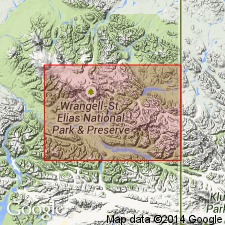
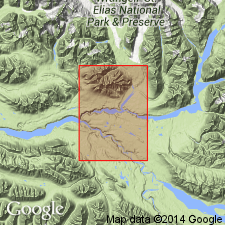
Named for Chititu Creek in southeastern part of McCarthy B-5 quad. Type area designated as exposures in northwestern part of McCarthy A-4 quad, north and south of Young Creek, and southern part of B-4 quad, south of latitude of Copper Creek, AK. Good reference sections extend north and south of Young Creek about 4 miles east of western border of A-4 quad. Composed of gray to black mudstone and shale. Consists of minor amounts of porcellanite, impure chert, and fine-grained sandstone, and uncommon thin beds and lenses of impure limestone. Calcareous concretions of diverse sizes are locally abundant. Thickness at reference section is about 5500 ft. Conformably overlies Kennicott Formation. Conformably underlies MacColl Ridge Formation (new). Contains pelecypod INOCERAMUS. Megafossils indicate formation is mainly Late Cretaceous, with and age span extending from at least Cenomanian to late Campanian. Base of formation appears to vary from place to place and may be as old as early Albian along lower Nizina River, latest Albian near Copper Creek, and as young as Coniacian along MacColl Ridge. Assigned Late Cretaceous age.
Source: GNU records (USGS DDS-6; Menlo GNULEX).
- Usage in publication:
-
- Chititu Formation*
- Modifications:
-
- Age modified
- AAPG geologic province:
-
- Alaska Southern region
Summary:
Age shown as Early and Late Cretaceous on map explanation.
Source: GNU records (USGS DDS-6; Menlo GNULEX).
For more information, please contact Nancy Stamm, Geologic Names Committee Secretary.
Asterisk (*) indicates published by U.S. Geological Survey authors.
"No current usage" (†) implies that a name has been abandoned or has fallen into disuse. Former usage and, if known, replacement name given in parentheses ( ).
Slash (/) indicates name conflicts with nomenclatural guidelines (CSN, 1933; ACSN, 1961, 1970; NACSN, 1983, 2005, 2021). May be explained within brackets ([ ]).