

- Usage in publication:
-
- Chapin Wash formation*
- Modifications:
-
- Named
- Dominant lithology:
-
- Sandstone
- Siltstone
- Mudstone
- Clay
- AAPG geologic province:
-
- Plateau sedimentary province
Summary:
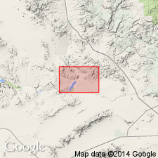
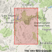
Named as a formation in the Artillery Mountains manganese area for exposures along Chapin Wash, Mohave Co, AZ, Plateau sedimentary province. No type locality designated. Crops out roughly in the form of an elongated "U," 6-7 mi long and 3-5 mi wide, outlining shallow syncline that occupies valley between Rawhide and Artillery Mountains in west-central AZ. Was formerly part of Lee's (1908) Temple Bar conglomerate (not used). In general, consists of alluvial-fan and playa deposits ranging from 0 to possibly 1,500 ft or more. Mainly is of pink to red and brown clay, mudstone, siltstone, and sandstone, with gradations into one another. Includes lesser amounts of conglomerate, limestone, and white to gray, finely laminated tuff. The sandstones vary from red, brown, to gray; they may be arkosic, tuffaceous, pumiceous, fine grained. The conglomerate may be poorly consolidated, tuffaceous, pumiceous. Unconformably overlies rocks as old as pre-Cambrian; in part conformably underlies Cobwebb basalt (new) and in part unconformably underlies Sandtrap conglomerate (new) and younger rocks. Structure map. Geologic maps. Measured sections. Columnar sections. Chapin Wash formation tentatively assigned to early Pliocene because it is oldest of the formations of the manganese basin, and all of these formations are assigned to the Pliocene. Deposited in a closed basin or bolson. Palm roots and fragments of a canid jaw.
Source: GNU records (USGS DDS-6; Denver GNULEX).
- Usage in publication:
-
- Chapin Wash Formation
- Modifications:
-
- Overview
- Dominant lithology:
-
- Breccia
- Sandstone
- Conglomerate
- Siltstone
- Limestone
- AAPG geologic province:
-
- Plateau sedimentary province
Summary:
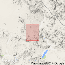
Best exposures are near the Rawhide mine and at Rankin Wash, Mohave Co, AZ in the Plateau sedimentary province. Geologic map shows distribution in the Rawhide Mountains. Consists of a chaotic assemblage at least 1,000 m thick of sedimentary rocks (mostly thin- to thick-bedded arkosic red sandstone and conglomerate, and minor amount of siltstone and limestone) interlayered with monolithologic breccias (coherent bodies of rock composed of angular debris from a single igneous or metamorphic parent), and volcanic rocks (black amygdaloidal basalt and purple latite). Some of the breccias consist of pink granite gneiss, quartz-biotite schist, quartz-orthoclase gneiss, quartz-mica schist and granite. Cross-bedding, graded bedding, ripple marks, rip-up clasts, and soft-sediment deformation common in the sedimentary rocks. Lies unconformably on Artillery Formation. Nonmarine origin. Of middle to late Miocene age. Postdates extrusion of a 15.9 m.y. basalt of Artillery. Unconformably overlain by a probable late Tertiary basalt.
Source: GNU records (USGS DDS-6; Denver GNULEX).
- Usage in publication:
-
- Chapin Wash Formation
- Modifications:
-
- Not used
Summary:
Many of the units given informal designations under the heading "Rocks deposited in basins not related to present topography" were assigned to the Artillery and Chapin Wash Formations by Lasky and Webber (1949). Their nomenclature is not followed because: 1) the lithologic descriptions of the formations are similar and not useful for mapping; 2) this report recognized many lithologically distinctive and mappable units in each of the original formations; 3) the regional unconformities Lasky and Webber used to distinguish Artillery from Chapin Wash are local; and 4) the base of the Tertiary sequence is late Oligocene, not Eocene, the proposed age of the Artillery. The authors' work in this and in the four adjoining quads indicates the rocks are late Oligocene and Miocene because: 1) the K-Ar age determinations on the older basalt sequence range from 16.5 to 18.7 m.y.; 2) the basalts are interbedded with 18.5 Ma Peach Springs Tuff; 3) K-R determinations on silicic volcanic rocks are mostly 12 to 13 m.y.; and 4) rocks from the lower part of the sequence yielded 39Ar/40Ar ages of about 26.5 Ma on sanidine and biotite.
Source: GNU records (USGS DDS-6; Denver GNULEX).
For more information, please contact Nancy Stamm, Geologic Names Committee Secretary.
Asterisk (*) indicates published by U.S. Geological Survey authors.
"No current usage" (†) implies that a name has been abandoned or has fallen into disuse. Former usage and, if known, replacement name given in parentheses ( ).
Slash (/) indicates name conflicts with nomenclatural guidelines (CSN, 1933; ACSN, 1961, 1970; NACSN, 1983, 2005, 2021). May be explained within brackets ([ ]).