

- Usage in publication:
-
- Carter Creek formation
- Modifications:
-
- Original reference
- Dominant lithology:
-
- Sandstone
- Siltstone
- Mudstone
- AAPG geologic province:
-
- Montana folded belt
Summary:
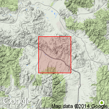
Carter Creek formation. Consists of 4,500 to 6,000 feet of intercalated marine, brackish, and fresh-water deposits between Jens formation (new) and overlying unconformable Golden Spike conglomerate or facies of Elkhorn Mountain volcanics. Calculated thickness along Carter Creek syncline, in T. 10 N., R. 11 W., is 5,700 to 6,000 feet. Lower 2,000 feet is composed of sandstone, siltstone, and silty mudstone, and some interbedded dark shale of marine aspect. Varicolored beds in westernmost sections, probably indicating continental or brackish water conditions. Includes a few lenses of coarse-grained conglomeratic dacitic tuff 1,500 feet below top. Is probably equivalent to Kevin member of Marias River shale. Age is Cretaceous.
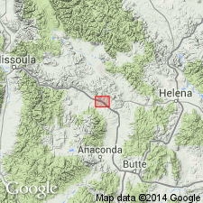
Named from Carter [Carten] Creek, a south-flowing tributary of Clark Fork River, 13 mi southeast of Drummond, Granite Co., MT. Type locality not designated due to lack of suitable exposures in map area; all exposures are incomplete.
[U.S. Board on Geographic Names changed name from Carter Creek to Carten Creek in 1960; uncertain when this change appeared on topographic maps.]
Source: US geologic names lexicon (USGS Bull. 1350, p. 124); GNU records (USGS DDS-6; Denver GNULEX).
- Usage in publication:
-
- Carter Creek formation
- Modifications:
-
- Principal reference (area)
- AAPG geologic province:
-
- Montana folded belt
Summary:
Pg. 48-49. Carter Creek formation. Type area noted. Poorly known because of inadequate exposure. Occurs only in deeper parts of Carter Creek and Gold Creek synclines between Jens and Garrison.
Type area: between Brock and Carter [Carten] Creeks. Named from Carter [Carten] Creek, a south-flowing tributary of Clark Fork River, 13 mi southeast of Drummond, Granite Co., MT. Partial section (lower 778 ft) measured in NE/4 sec. 20, T. 10 N., R. 11 W., east of Jens, [Granite Co.], MT.
Source: US geologic names lexicon (USGS Bull. 1350, p. 124).
- Usage in publication:
-
- Carten Creek Formation*
- Modifications:
-
- Age modified
- Dominant lithology:
-
- Sandstone
- Siltstone
- Mudstone
- AAPG geologic province:
-
- Montana folded belt
Summary:
Originally spelled Carter Creek by Gwinn (1961); changed to Carten Creek to conform to U.S. Board on Geographic Names [BGN changed name from Carter Creek to Carten Creek in 1960; uncertain when this change appeared on topographic maps]. Unit mapped undivided with several Cretaceous and Jurassic sedimentary rocks. Age is Late Cretaceous; basis of age determination not discussed. [Follows definition of Gwinn (1961).]
[Carten Creek Formation not adopted by the Montana Geol. Survey.]
Source: Modified from GNU records (USGS DDS-6; Denver GNULEX); MT Geol. Survey (written commun., 2007).
- Usage in publication:
-
- Carten Creek Formation*
- Modifications:
-
- Age modified
- AAPG geologic province:
-
- Montana folded belt
Summary:
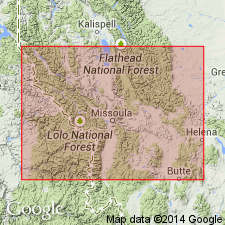
Carten Creek Formation [=Carter Creek Formation of Montana geologists]. Occurs in area of Drummond, Granite County, Montana, and Anaconda, Deer Lodge County, Montana, south of Lewis and Clark line, a west- and northwest-trending fault zone in west-central Montana. Overlies Jens Formation; underlies Golden Spike Formation. Top of unit inferred to be at least early Campanian age based on inferred age of the overlying Golden Spike. [Age of lower part of Golden Spike Formation inferred to be early Campanian based on correlation with lower part of Elkhorn Mountains Volcanics (citing Robinson and others, 1968, GSA Memoir 116, p. 566-568; they reported an isotopic age of about 80 Ma for upper part of the lower member of Elkhorn Mountains).] Correlates with part of Kevin Member of Marias River Shale, Telegraph Creek Formation, Virgelle Sandstone, and part of Two Medicine Formation of Wolf Creek area, on north side of Lewis and Clark line, in Lewis and Clark and Cascade Counties, Montana.
Source: Modified from GNU records (USGS DDS-6; Denver GNULEX).
For more information, please contact Nancy Stamm, Geologic Names Committee Secretary.
Asterisk (*) indicates published by U.S. Geological Survey authors.
"No current usage" (†) implies that a name has been abandoned or has fallen into disuse. Former usage and, if known, replacement name given in parentheses ( ).
Slash (/) indicates name conflicts with nomenclatural guidelines (CSN, 1933; ACSN, 1961, 1970; NACSN, 1983, 2005, 2021). May be explained within brackets ([ ]).