

- Usage in publication:
-
- Carmen formation
- Modifications:
-
- Named
- Dominant lithology:
-
- Shale
- Sandstone
- Conglomerate
- Lignite
- AAPG geologic province:
-
- Idaho Mountains province
Summary:
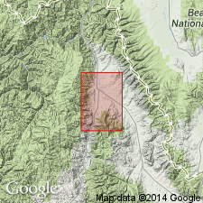
Probably named for town of Carmen, Lemhi Co, ID in Idaho Mountains province; formerly called Salmon "lake beds." No type locality given. Occurs entirely within the Salmon Basin which is named for the town near its center and for the Salmon River in Lemhi Co. Consists of moderately well-indurated, thin-bedded, fine-grained clastic rocks--mostly shales with a considerable amount of intercalated sandstone and locally some conglomerate and lignite. Except for lignitic beds, rocks are light colored, mostly white or light gray. The conglomerates are largely confined to base of the formation; most striking exposures are several miles north of Salmon quadrangle where beds more than 100 ft thick crop out along main highway. Beds of sandstone rather abundant throughout the formation; beds are rather thin, rarely more than a foot or two, but in some places 4-5 ft thick. Shales are the most abundantly exposed rocks in formation; some of shale beds are highly siliceous, some are composed of thinly laminated clay. All shales contain bits of quartz, feldspar, mica, and variable amounts of volcanic ash as well as clay. Carmen is in contact with the Challis volcanics in south part of map. Covered by Quaternary alluvium. Bulk of formation derived from tuffaceous beds in upper part of Challis. Plant fossils listed. Geologic map. Correlates with Payette formation of southwestern ID. Of early Miocene age.
Source: GNU records (USGS DDS-6; Denver GNULEX).
- Usage in publication:
-
- Carmen formation
- Modifications:
-
- Contact revised
- AAPG geologic province:
-
- Idaho Mountains province
Summary:
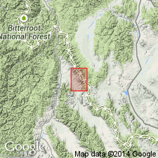
Lower contact revised in that the Carmen is underlain by the newly named upper Oligocene? Geertson formation in the Baker quad, Lemhi Co, ID in the Idaho Mountains province. Carmen, several hundred ft thick, barely extends into the quad. Fossils [type not stated] indicate an early Miocene age. Geologic map.
Source: GNU records (USGS DDS-6; Denver GNULEX).
- Usage in publication:
-
- Carmen formation
- Modifications:
-
- Not used
Summary:
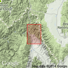
Discontinued as a name in Lemhi Co, ID, Idaho Mountains province because as defined included three unconformable formations. Also name Carmen has been applied to a formation at another locality. Replaced by new name Kirtley Formation.
Source: GNU records (USGS DDS-6; Denver GNULEX).
For more information, please contact Nancy Stamm, Geologic Names Committee Secretary.
Asterisk (*) indicates published by U.S. Geological Survey authors.
"No current usage" (†) implies that a name has been abandoned or has fallen into disuse. Former usage and, if known, replacement name given in parentheses ( ).
Slash (/) indicates name conflicts with nomenclatural guidelines (CSN, 1933; ACSN, 1961, 1970; NACSN, 1983, 2005, 2021). May be explained within brackets ([ ]).