

- Usage in publication:
-
- Carbonado formation*
- Modifications:
-
- Named
- Biostratigraphic dating
- Dominant lithology:
-
- Sandstone
- Shale
- Coal
- AAPG geologic province:
-
- Puget Sound province
Summary:
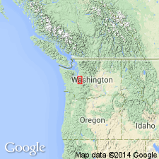
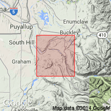
Named for town of Carbonado along Carbon River in north-central Pierce Co, WA. [No type given but] detailed stratigraphic sections from exposures along Carbon River show composition of mainly sandstone, with subordinate shale. Is as much as 1150 ft thick. Appears to be conformable beneath Wilkeson formation (new) of Puget group. Is lowest formation in Puget "formation" [also called "Puget series" and "Puget group"]. From fossil plants, "Knowlton ... report[s] ... lower beds of the series [presumably Carbonado formation] are Eocene ...".
Source: GNU records (USGS DDS-6; Menlo GNULEX).
- Usage in publication:
-
- Carbonado Formation*
- Modifications:
-
- Age modified
- Biostratigraphic dating
- Reference
- AAPG geologic province:
-
- Puget Sound province
Summary:
Occupies northward-trending belt in eastern third of Lake Tapps 15' quad. Reference section designated west of Carbonado along Carbon River Canyon in secs.4-5 T18N R6E and secs.31-32 T19N R6E, Pierce Co, WA. Detailed measured section of formation in this area given by Weaver (1937, p.64-66). Consists of interbedded sandstone (less than half), siltstone, mudstone, and shale, more than 5000 ft thick. [Conformably] overlain by Northcraft Formation (new) of Puget Group at lowermost contact of volcanic sedimentary rocks of Northcraft. Basal contact not seen. Is indistinguishable from Spiketon Formation (new) of Puget Group except where the two are separated by Northcraft Formation. "Includes beds of Willis' [1898] Carbonado and Wilkeson Formation and the lower part of his Burnett Formation." Fossil leaves are believed by R.W. Brown to represent "latter half of Eocene", whereas J.A. Wolfe believes formation "is probably no younger than middle Eocene". Age considered to be middle(?) Eocene.
Source: GNU records (USGS DDS-6; Menlo GNULEX).
For more information, please contact Nancy Stamm, Geologic Names Committee Secretary.
Asterisk (*) indicates published by U.S. Geological Survey authors.
"No current usage" (†) implies that a name has been abandoned or has fallen into disuse. Former usage and, if known, replacement name given in parentheses ( ).
Slash (/) indicates name conflicts with nomenclatural guidelines (CSN, 1933; ACSN, 1961, 1970; NACSN, 1983, 2005, 2021). May be explained within brackets ([ ]).