

- Usage in publication:
-
- Butte gravels
- Modifications:
-
- Named
- Biostratigraphic dating
- Dominant lithology:
-
- Gravel
- Clay
- Sand
- Limestone
- Sandstone
- AAPG geologic province:
-
- Sacramento basin
Summary:
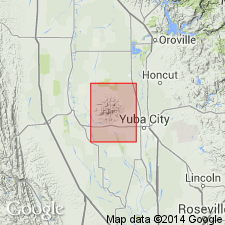
Butte gravels occur in Marysville Buttes [also known as Sutter Buttes] which lie between Sacramento and Feather Rivers in Sutter Co, CA. Consists essentially of gravels, often current-bedded, with thin seams of laminated, ferruginous clays and sands and two conspicuous hard beds each about 4 feet thick, one a gray limestone and sandstone, 150 feet above base, the other a brown-weathering, fossiliferous sandstone, 700 feet above base. Thickness ranges from 450 to 1200 feet. Thickest development is along West Butte Pass. Overlies Ione sands [also referred to as White Ione sands) with minor disconformity but occasionally with erosion unconformity. [Conformably] underlies Sutter formation. Age is middle Eocene based on fossils assigned to Meganos by B.L. Clark.
Source: GNU records (USGS DDS-6; Menlo GNULEX).
- Usage in publication:
-
- Butte gravel member*
- Modifications:
-
- Adopted
- Revised
- Age modified
- AAPG geologic province:
-
- Sacramento basin
Summary:
Butte gravels of Williams (1929) is revised as sporadic basal Butte gravel member of Sutter formation. It is restricted to coarse gravels, possibly 135 ft thick in area looking west along West Butte Pass where gravels form foreground and two rounded hills. As restricted unit probably does not contain fossils. Age is considered late Tertiary but may be older, possibly late early Tertiary based on relationship to Sutter formation.
Source: GNU records (USGS DDS-6; Menlo GNULEX).
For more information, please contact Nancy Stamm, Geologic Names Committee Secretary.
Asterisk (*) indicates published by U.S. Geological Survey authors.
"No current usage" (†) implies that a name has been abandoned or has fallen into disuse. Former usage and, if known, replacement name given in parentheses ( ).
Slash (/) indicates name conflicts with nomenclatural guidelines (CSN, 1933; ACSN, 1961, 1970; NACSN, 1983, 2005, 2021). May be explained within brackets ([ ]).