

- Usage in publication:
-
- Buchanan gravel*
- Modifications:
-
- Overview
- AAPG geologic province:
-
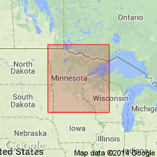
- Iowa shelf
Summary:
Leverett (p. 22) presents the following discussion regarding the origin and age of the Buchanan in IA (Iowa shelf). "The reports of the Iowa Geological Survey contain frequent references to what is termed Buchanan gravel, from exposures noted by Calvin (1876) in Buchanan County, Iowa. Although originally called an interglacial deposit, the descriptions given generally relate to gravel that seems to have been closely connected with the Kansan glaciation. In some places it may have been laid down as outwash from the ice sheet, but in quite as many other places the gravel deposits were involved in the till. The term has also been applied to gravel laid down as a secondary deposit along valleys that were excavated in the Kansan till. In general the Kansas drift is remarkably free from deposits that are to be interpreted as outwash, throughout its wide exposure in Kansas, Nebraska, Missouri, and Minnesota. The drainage from its border appears to have been generally sluggish during the recession of the border from central Missouri northward across Iowa into Minnesota. One of the few places where deposits that seem to be outwash have been noted is that in southern Mower County, Minnesota, in which the gravel pit above described (p. 21) was opened."
Source: GNU records (USGS DDS-6; Denver GNULEX).
- Usage in publication:
-
- Buchanan Gravel*
- Modifications:
-
- Areal extent
- Overview
- AAPG geologic province:
-
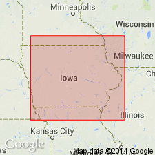
- Iowa shelf
Summary:
Mapped in northeastern IA (Iowa shelf). Light-brown, brownish-red, or grayish-brown, coarse to fine arkosic sand and gravel, locally containing scattered cobbles and boulders. Poorly sorted; well stratified, mostly horizontally bedded; some lenticular beds cross-bedded. Includes clay balls and masses of till in places. Pebbles chiefly basalt, diabase, greenstone, granite, chert, sandstone, and siltstone; some gabbro, syenite, quartz, quartzite, schist, shale, ironstone, and jasper. Most clasts <1.5 cm diameter; some 1.5-5 cm. Scattered cobbles and boulders, mostly greenstone and granite; boulders mostly 45-60 cm diameter; few are 1 m. Clasts and grains coated with iron oxide that locally cements deposit to form sandstone or conglomerate. All limestone and dolomite clasts and all primary matrix carbonate leached from outcrops; depth of leaching about 6 m, locally 16 m. Boulders commonly coated with secondary carbonate. Deposit occurs at ground surface or at base of a till. Locally fills buried valleys cut in bedrock. Locally is folded and sheared or thrust into overlying till. Most deposits considered to have been initially pre-Illinoian outwash of one or more glaciations; those at surface overlie extensive stepped erosion surfaces and are interpreted either as exhumed from beneath a till during formation of an erosion surface or of subsequent alluvial or glaciofluvial origin. Thickness 2-10 m; typically 5-6 m.
Source: GNU records (USGS DDS-6; Denver GNULEX).
For more information, please contact Nancy Stamm, Geologic Names Committee Secretary.
Asterisk (*) indicates published by U.S. Geological Survey authors.
"No current usage" (†) implies that a name has been abandoned or has fallen into disuse. Former usage and, if known, replacement name given in parentheses ( ).
Slash (/) indicates name conflicts with nomenclatural guidelines (CSN, 1933; ACSN, 1961, 1970; NACSN, 1983, 2005, 2021). May be explained within brackets ([ ]).