

- Usage in publication:
-
- Brower Creek volcanic member*
- Modifications:
-
- Mapped 1:62.5k
- Dominant lithology:
-
- Volcanic breccia
- AAPG geologic province:
-
- Sierra Nevada province
Summary:
Brower Creek volcanic member of Mariposa formation. Very coarse heterogeneous volcanic breccia in vicinity of Fowler Lookout; elsewhere ranges from very fine tuff to coarse breccia; contains pillow lava near Bear Creek. Age is Late Jurassic. Report includes cross section.
Source: US geologic names lexicon (USGS Bull. 1350, p. 93-94).
- Usage in publication:
-
- Brower Creek volcanic member*
- Modifications:
-
- Named
- Dominant lithology:
-
- Breccia
- AAPG geologic province:
-
- Sierra Nevada province
Summary:
Pg. 12, 19, 23-24, 25, pls. 1-11 (see also L.D. Clark and others, 1963, San Andreas quadrangle, USGS Geol. Quad. Map GQ-222). Brower Creek volcanic member of Mariposa formation. Name applied to sequence of volcanic rocks, chiefly coarse dark-green volcanic breccia, that forms part of Mariposa formation north of Stanislaus River. Member is thickest near Fowler Lookout, where it apparently represents an accumulation in vicinity of a vent. Northwest of lookout, member divides into two tongues that are interlayered with epiclastic rocks of Mariposa formation. Member is surrounded on three sides by epiclastic rocks continuous on surface with type area of Mariposa. Exposures are on western flank of syncline, and beds dip steeply. Near Mokelumne River, Mariposa formation is about 4,000 feet thick of which nearly all is Brower Creek. Overlaps Logtown Ridge formation between Drytown and Mokelumne River. Unit was mapped as diabase and porphyrite by Turner (1894, USGS Geol. Atlas of the US folio, no. 11) and was included in Logtown Ridge formation by Eric and others (1955, California Div. Mines Spec. Rpt., no. 41). Age of Mariposa formation is Late Jurassic (late Oxfordian to early Kimmeridgian) based on fossils identified by R.W. Imlay (written commun., 1959) [USGS Preliminary Report on Referred Fossils MD-59-14, May 20, 1959]. Fossil list included.
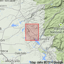
Named for Brower Creek, whose headwaters are near Fowler Lookout on lower western slopes of the Sierra Nevada, Calaveras Co., CA. Extends northwestward beyond Mokelumne River but probably not as far northwestward as Cosumnes River.
[Author does not capitalize rank terms; however, units are considered formal.]
Source: US geologic names lexicon (USGS Bull. 1350, p. 93-94); supplemental information from GNU records (USGS DDS-6; Menlo GNULEX).
- Usage in publication:
-
- Brower Creek Volcanic Member*
- Modifications:
-
- Overview
- AAPG geologic province:
-
- Sierra Nevada province
Summary:
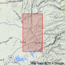
Three distinct lithologies of unit shown on geologic map of western Sierra foothills between Cosumnes and Mokelumne Rivers, Amador Co, CA. Detailed lithologic description included in text.
Source: GNU records (USGS DDS-6; Menlo GNULEX).
For more information, please contact Nancy Stamm, Geologic Names Committee Secretary.
Asterisk (*) indicates published by U.S. Geological Survey authors.
"No current usage" (†) implies that a name has been abandoned or has fallen into disuse. Former usage and, if known, replacement name given in parentheses ( ).
Slash (/) indicates name conflicts with nomenclatural guidelines (CSN, 1933; ACSN, 1961, 1970; NACSN, 1983, 2005, 2021). May be explained within brackets ([ ]).