

- Usage in publication:
-
- Brock shale*
- Modifications:
-
- Original reference
- Dominant lithology:
-
- Shale
- AAPG geologic province:
-
- Klamath Mountains province
Summary:
Brock shale. Conformably overlies Hosselkus limestone in Brock Mountain, whence the name, and has a thickness of about 400 feet. In lower 300 feet or more adjoining the limestone the shales are dark, somewhat calcareous, and frequently contain HALOBIA. Above these come sandy shales, gray and reddish in color, and characterized locally by PSEUDOMONOTIS SUBCIRCULARIS. Is overlain, probably unconformably, by Modin formation. [Brock shale is approx. = Swearinger slate.] Age is Late Triassic.
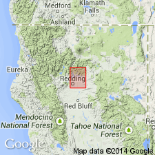
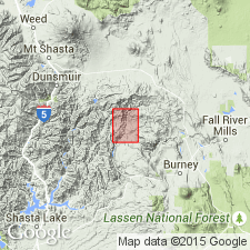
Named from exposures on Brock Mountain, Redding quadrangle, scale 1:125,000 (1901 ed.), Shasta Co., northern CA.
[Brock Mountain (now Gray Rocks, https://edits.nationalmap.gov/apps/gaz-domestic/public/search/names/260833) is located between Squaw Creek (now Sulanharas Creek) and Pit River, about 2 mi southeast of Winnibulli Mountain, in secs. 5 and 8, T. 34 N., R. 2 W., approx. Lat. 40 deg. 49 min. 45 sec. N., Long. 122 deg. 07 min. 00 sec. W., Devils Rock 7.5-min quadrangle, Shasta National Forest / Whiskeytown-Shasta-Trinity National Recreation Area, Shasta Co., northern CA. (Additional locality information from USGS GNIS database and USGS historical topographic map collection TopoView, accessed on September 4, 2023).]
Source: US geologic names lexicon (USGS Bull. 896, p. 270).
- Usage in publication:
-
- Brock shale
- Modifications:
-
- Revised
- AAPG geologic province:
-
- Klamath Mountains province
Summary:
Pg. 6 (figs. 3, 4), 7-8, pl. 1. Underlies Hawkins Creek member (new) of Modin formation (redefined); overlies Hosselkus limestone. Estimated thickness 400 feet. Age is Late Triassic.
See also [1953], Stanford Univ. Abs. Dissert., v. 27, p. 436.
Source: US geologic names lexicon (USGS Bull. 1200, p. 486-487).
For more information, please contact Nancy Stamm, Geologic Names Committee Secretary.
Asterisk (*) indicates published by U.S. Geological Survey authors.
"No current usage" (†) implies that a name has been abandoned or has fallen into disuse. Former usage and, if known, replacement name given in parentheses ( ).
Slash (/) indicates name conflicts with nomenclatural guidelines (CSN, 1933; ACSN, 1961, 1970; NACSN, 1983, 2005, 2021). May be explained within brackets ([ ]).