

- Usage in publication:
-
- Bright Angel shale*
- Modifications:
-
- Original reference
- Dominant lithology:
-
- Quartzite
- Sandstone
- Limestone
- AAPG geologic province:
-
- Plateau sedimentary province
Summary:
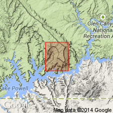
Bright Angel shale of Tonto group. Soft, greenish, micaceous, fossiliferous, sandy shale with two thin layers of brown crystalline limestone locally present in middle of formation. Thickness 25 to 375 feet. Consists of (descending): (1) alternating layers of shale and purplish brown sandstone underlain by soft, greenish, micaceous sandy shale, 13 feet; (2) snuff-colored limestone, locally known as "Snuffy limestone" 57 feet, including 25 feet of soft shale; (3) soft, green, micaceous sandy shale and thin sandstones, 160 feet. Middle formation of Tonto group. Conformably underlies Muav limestone and conformably overlies Tapeats sandstone. Age is Middle Cambrian. Report includes geologic map.
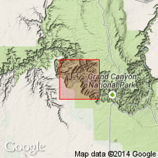
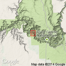
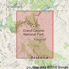
Named from Bright Angel Canyon, in walls of which the formation is well exposed, Grand Canyon, [Bright Angel quadrangle], Coconino Co., northern AZ.
Measured section 348 ft on north side Colorado River between Hakatai and Burro Canyons.
Source: US geologic names lexicon (USGS Bull. 896, p. 266); supplemental information from GNU records (USGS DDS-6; Denver GNULEX).
- Usage in publication:
-
- Bright Angel shale*
- Modifications:
-
- Revised
- AAPG geologic province:
-
- Plateau sedimentary province
Summary:
Bright Angel shale of Tonto group. Transferred from Muav limestone to Bright Angel shale 58 [68?] feet of shaly beds containing near base a few beds of mottled limestone similar to the mottled limestones of Muav limestone. Age is Middle Cambrian.
Source: US geologic names lexicon (USGS Bull. 896, p. 266).
- Usage in publication:
-
- Bright Angel shale
- Modifications:
-
- Revised
- AAPG geologic province:
-
- Plateau sedimentary province
Summary:
Pg. 17, 20-21, 80-84. Bright Angel shale of Tonto group. Thickness varies considerably from place to place owing to lateral changes in lithology along time planes. Both base and top of formation rise stratigraphically, but at irregular rate, from west to east. Thickness 325 feet at type locality. Intertongues with Muav limestone to west. Includes Flour Sack member (new) and Meriwitica and Tincanebits tongues (new). Fossils (trilobites, brachiopods, fucoid-like casts, worm borings) common. [Age is considered Early and Middle Cambrian.]
Source: US geologic names lexicon (USGS Bull. 1200, p. 480); supplemental information from GNU records (USGS DDS-6; Menlo GNULEX, Denver GNULEX), GNC index card files.
- Usage in publication:
-
- Bright Angel Shale*
- Modifications:
-
- Areal extent
- Age modified
- AAPG geologic province:
-
- Mojave basin
- Great Basin province
Summary:
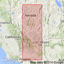
Bright Angel Shale is recognized in the "eastern region of the southern Great Basin" where it is correlated with the Carrara Formation. Age is Early and Middle Cambrian.
Source: GNU records (USGS DDS-6; Menlo GNULEX).
- Usage in publication:
-
- Bright Angel Shale*
- Modifications:
-
- Areal extent
- AAPG geologic province:
-
- Plateau sedimentary province
Summary:
The name Middle Cambrian Bright Angel Shale geographically extended northward from AZ into the subsurface of Kane Co, UT, Plateau sedimentary province, where Bright Angel overlies Middle and Lower Cambrian Tapeats Sandstone and underlies Middle Cambrian Muav Limestone. Bright Angel is 676 ft thick and is composed mostly of red, green, and gray, glauconitic, calcareous, dolomitic, silty shale. Also includes siltstone, silty to pebbly sandstone. The gray oolitic and pelletal dolomitic limestone and minor dolomite beds included in the 676 ft section are tongues of the overlying Muav. Columnar section. Marine deposit.
Source: GNU records (USGS DDS-6; Denver GNULEX).
- Usage in publication:
-
- Bright Angel Schist*
- Modifications:
-
- Redescribed
- Revised
- Areal extent
- Dominant lithology:
-
- Schist
- AAPG geologic province:
-
- Salton basin
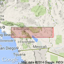
Summary:
Names applied in Grand Canyon area extended geographically to sequence in Big Maria Mountains of southeast CA, Salton basin, with change of lithic designation. Cambrian Bright Angel Shale changed to Bright Angel Schist. Bright Angel in Big Maria Mountains consists of dark-green mica chlorite schist in southeastern part of mountains and of brilliantly specular dark coarse-grained biotite schist elsewhere. Fine-grained quartzite in layers typically a few inches thick intercalated with schist. Is 0.5 to 130 m thick. Contacts revised; overlies Tapeats Quartzite (redefined); underlies Muav Marble (redefined). Equivalent to lower part of Abrigo Formation of southern AZ. This part of CA was part of the stable craton of North America in Paleozoic and early Mesozoic time.
Source: GNU records (USGS DDS-6; Denver GNULEX).
- Usage in publication:
-
- Bright Angel Shale
- Modifications:
-
- Geochronologic dating
- AAPG geologic province:
-
- Mojave basin
Summary:
Pg. 5, geologic time scale (inside front cover). Bright Angel Shale (Cambrian). Two samples collected from metamorphosed Bright Angel Shale [Bright Angel Schist] in Kilbeck Hills and Old Women Mountains, San Bernardino Co., CA. Calculated ages suggest Late Cretaceous metamorphic event; decay constants, recommended by the IUGS Subcommission on Geochronology (Steiger and Jager, 1977, Earth and Planetary Science Letters, v. 36, p. 359-362) are used. Ages determined by USGS personnel in Denver, CO (R.F. Marvin, H.H. Mehnert, E.A. Brandt). Samples submitted by K.A. Howard; previously published by Miller and others (1982).
(1) Sample from biotite schist. K-Ar age on biotite 71.0 +/-2.6 Ma; on muscovite 72.3 +/-1.7 Ma. Sample no. USGS(D)PS78-9. Sample locality: Kilbeck Hills, Lat. 34 deg. 21 min. 31 sec. N., Long. 115 deg. 17 min. 58 sec. W., in SE/4 sec. 9, T. 3 N., R. 16 E., Chubbuck 7.5-min quadrangle, San Bernardino Co., CA.
(2) Sample from phyllitic schist. K-Ar age on biotite 68.7 +/-2.5 Ma; on muscovite 68.5 +/-1.6 Ma. Sample no. USGS(D)OW79(CM). Sample locality: Old Women Mountains, Lat. 34 deg. 32 min. N., Long. 115 deg. 10 min. W., Essex 15-min quadrangle, San Bernardino Co., CA (exact location not known).
Miller and others, 1982, Mesozoic thrusting, metamorphism, and plutonism, Old Woman-Piute Range, southeastern California: San Diego, CA, Cordilleran Publishers, p. 561-581.
Source: Publication.
For more information, please contact Nancy Stamm, Geologic Names Committee Secretary.
Asterisk (*) indicates published by U.S. Geological Survey authors.
"No current usage" (†) implies that a name has been abandoned or has fallen into disuse. Former usage and, if known, replacement name given in parentheses ( ).
Slash (/) indicates name conflicts with nomenclatural guidelines (CSN, 1933; ACSN, 1961, 1970; NACSN, 1983, 2005, 2021). May be explained within brackets ([ ]).