

- Usage in publication:
-
- Bragdon formation*
- Modifications:
-
- Original reference
- Dominant lithology:
-
- Slate
- Quartzite
- AAPG geologic province:
-
- Klamath Mountains province
Summary:
Pg. 236, 238. "Upper slates" or Bragdon formation. The latest of the formations included in "Auriferous slate series." Consists of 2,000 feet of alternating thin-bedded slates and thick-bedded blue quartzites; no limestone. Similar to Mariposa slates. [Age is] tentatively assigned to Jurassic.
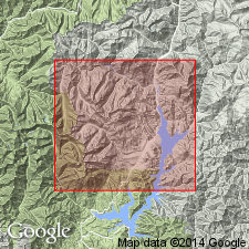
Exposures in Bragdon Gulch and vicinity of Bragdon, on Trinity River 8 mi south of Trinity Center, Weaverville quadrangle, northwestern CA. Named from community of Bragdon. Formation occurs as an arcuate band 17 mi long and as much as 4 mi wide at north end of West Shasta district, Shasta Co., CA.
Source: US geologic names lexicon (USGS Bull. 896, p. 249; 1200, p. 451).
- Usage in publication:
-
- Bragdon formation*
- Modifications:
-
- Revised
- Age modified
- AAPG geologic province:
-
- Klamath Mountains province
Summary:
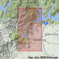
According to J.S. Diller, the Bragdon formation is 2,000 to 6,000 feet thick in Redding quadrangle, it underlies Baird formation, unconformably overlies Kennett formation, and [age is] Mississippian.
Source: US geologic names lexicon (USGS Bull. 896, p. 249).
- Usage in publication:
-
- Bragdon formation*
- Modifications:
-
- Redescribed
- Overview
- Dominant lithology:
-
- Shale
- AAPG geologic province:
-
- Klamath Mountains province
Summary:
Pg. 1, 38-41, pl. 1. Bragdon formation. Composed of interstratified shale, siltstone, sandstone, grit, conglomerate, a small amount of rhyolite tuff, and a small flow of mafic lava. Beds of shale make up more than 75 percent of formation. Thickness 3,500 feet in mapped area; only lower part of formation present. Overlies Kennett formation, but, where Kennett was either not deposited or was locally eroded, the Bragdon rests upon either Balaklala rhyolite or Copley greenstone. Age is Mississippian.
Source: US geologic names lexicon (USGS Bull. 1200, p. 451).
For more information, please contact Nancy Stamm, Geologic Names Committee Secretary.
Asterisk (*) indicates published by U.S. Geological Survey authors.
"No current usage" (†) implies that a name has been abandoned or has fallen into disuse. Former usage and, if known, replacement name given in parentheses ( ).
Slash (/) indicates name conflicts with nomenclatural guidelines (CSN, 1933; ACSN, 1961, 1970; NACSN, 1983, 2005, 2021). May be explained within brackets ([ ]).