

- Usage in publication:
-
- Boyer Ranch Formation
- Modifications:
-
- Original reference
- Dominant lithology:
-
- Sandstone
- Conglomerate
- AAPG geologic province:
-
- Great Basin province
Summary:
Pg. 2554. Boyer Ranch Formation. Subdivided into informal conglomerate and quartz sandstone members. Conglomerate member composed of basal carbonate pebble conglomerate and minor interbedded pebbly sandstone and homogeneous quartz sandstone. The conglomerate matrix ix quartz sand and carbonate cement. Quartz sandstone member consists largely of quartz sandstone and sparsely of sandy limestone and dolomite. Thickness 0 to 110 m. Overlies unnamed siltstone, limestone, shale, and carbonate, with thrust fault and erosional unconformity. Underlies unnamed basalt, gabbro, rhyolitic rocks and Quaternary alluvium and landslides. Age is Middle Jurassic.
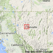
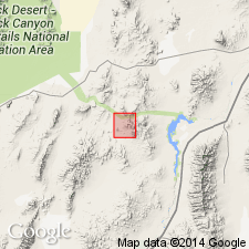
Type area: exposures in northern Clan Alpine Mountains, 3.2 km (about 2 mi) north of Shoshone Creek, Churchill Co., north-central NV (shown on geol. sketch map). Named from Boyer Ranch in Dixie Valley, about 15 mi northeast of type area, [Boyer Ranch 7.5-min quadrangle, Churchill Co., north-central NV]. Notable exposures in Hoyt and Cottonwood Canyons, northwestern Stillwater Range, Divine Meadows and Buena Vista Hills.
Source: GNU records (USGS DDS-6; Menlo GNULEX); US geologic names lexicon (USGS Bull. 1520, p. 37).
- Usage in publication:
-
- Boyer Ranch Formation*
- Modifications:
-
- Adopted
- Geochronologic dating
- AAPG geologic province:
-
- Great Basin province
For more information, please contact Nancy Stamm, Geologic Names Committee Secretary.
Asterisk (*) indicates published by U.S. Geological Survey authors.
"No current usage" (†) implies that a name has been abandoned or has fallen into disuse. Former usage and, if known, replacement name given in parentheses ( ).
Slash (/) indicates name conflicts with nomenclatural guidelines (CSN, 1933; ACSN, 1961, 1970; NACSN, 1983, 2005, 2021). May be explained within brackets ([ ]).