

- Usage in publication:
-
- Bootlegger Cove clay*
- Modifications:
-
- Named
- Dominant lithology:
-
- Clay
- AAPG geologic province:
-
- Alaska Southern region
Summary:
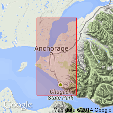
Named for exposures near Bootlegger Cove. Typical sections are in SW/4 NE/4 sec.23 T13N R4W, Bootlegger Cove, Anchorage area, southern Alaska. Exposed almost continuously from point about 0.75 mi southeast of Point Woronzof northward to point about 0.5 mi southwest of Eagle River Flats. Best exposed along Knik Arm west of Bootlegger Cove and Chester Creek (measured section included in report). Composed of blue-gray clay of lacustrine or estuarine origin. Thickness ranges from 14 to 126 ft. Underlies deposits of Naptowne glaciation. Age is pre-Wisconsin (Pleistocene).
Source: GNU records (USGS DDS-6; Menlo GNULEX).
- Usage in publication:
-
- Bootlegger Cove Formation*
- Modifications:
-
- Redescribed
- Age modified
- Dominant lithology:
-
- Silt
- Clay
- Sand
- AAPG geologic province:
-
- Alaska Southern region
Summary:
Bootlegger Cove Clay of Miller and Dobrovolny (1959) redescribed as Bootlegger Cove Formation of Updike and others (1982) is adopted. Composed predominantly of silt and clay interbedded with fine sandy silt, silty fine sand and sand and gravel near its margins. Age is late Pleistocene based on uranium and radiocarbon methods on shells from several locations in unit.
Source: GNU records (USGS DDS-6; Menlo GNULEX).
For more information, please contact Nancy Stamm, Geologic Names Committee Secretary.
Asterisk (*) indicates published by U.S. Geological Survey authors.
"No current usage" (†) implies that a name has been abandoned or has fallen into disuse. Former usage and, if known, replacement name given in parentheses ( ).
Slash (/) indicates name conflicts with nomenclatural guidelines (CSN, 1933; ACSN, 1961, 1970; NACSN, 1983, 2005, 2021). May be explained within brackets ([ ]).