

- Usage in publication:
-
- Bonner Quartzite*
- Modifications:
-
- Principal reference
- Dominant lithology:
-
- Quartzite
- AAPG geologic province:
-
- Northern Rocky Mountain region
Summary:
Pg. F195 (fig.), F199-F201; USGS Misc. Inv. Ser. Map I-296, 1959. Bonner quartzite of Missoula group. Distinctive pink, cross-bedded, feldspathic quartzite, includes minor interbedded argillite. Forms blocky rubble; outcrops relatively rare. Thickness 1,500 feet on north side of Mount Sentinel; 800 feet at type. Underlies McNamara argillite (restricted); overlies Miller Peak argillite (all included in Missoula group). Rocks previously included in middle member of McNamara formation by Clapp and Deiss (1931). Age is Precambrian (Belt).
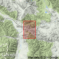
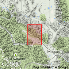
Type locality: in Lolo National Forest, Bonner quadrangle, Missoula Co., western MT. Well exposed on both sides of Blackfoot River just above town of Bonner [in sec. 15, T. 13 N., R. 18 W., southwestern corner Blue Point 7.5-min quadrangle, Missoula Co., western MT].
Source: Publication; US geologic names lexicon (USGS Bull. 1200, p. 426-427).
- Usage in publication:
-
- Bonner Quartzite
- Modifications:
-
- Reference
- AAPG geologic province:
-
- Northern Rocky Mountain region
Summary:
Name Missoula Group has been applied to all rocks in the Precambrian Belt Supergroup above the carbonate (Siyeh Formation of Glacier National Park or Helena Formation of Helena area). These same rocks were designated Camp Creek Series by Walcott in 1906, but that name has been little used and is abandoned in favor of Missoula in this report. The Camp Creek section is designated a reference section [but section not described] for the Missoula. The reference section is located along crest of the ridge parallel to and northwest of Camp Creek in secs 22, 28, and 33, T20N, R12W, Lewis and Clark Range, Powell Co, MT in Northern Rocky Mountain region where the following formations of the Missoula are exposed (ascending order): Snowslip, Shepard, and Shields Formations, Bonner Quartzite, McNamara and Garnet Range Formations. Geologic map.
Source: GNU records (USGS DDS-6; Denver GNULEX).

- Usage in publication:
-
- Bonner Quartzite*
- Modifications:
-
- Areal extent
- AAPG geologic province:
-
- Northern Rocky Mountain region
Summary:
Figs. 3, 4, 5. Bonner Quartzite of Missoula Group of Belt Supergroup. Geographically extended into: Helena area, central Montana, includes rocks previously called †Greenhorn Mountain Quartzite (abandoned), lies above Mount Shields Formation (†Marsh Formation) of Missoula Group; Missoula-St. Regis area, central western Montana, includes rocks previously called †Lupine Quartzite (abandoned), lies above Miller Peak Formation (†Spruce Formation) of Missoula Group. Age is Precambrian Y.
Source: Publication; Changes in stratigraphic nomenclature, 1972 (USGS Bull. 1394-A, p. A6-A7).

- Usage in publication:
-
- Bonner Quartzite*
- Modifications:
-
- Areal extent
- AAPG geologic province:
-
- Northern Rocky Mountain region
Summary:
Pg. A6-A7 (table 1), A9 (fig. 3), A16-A17. Bonner Quartzite of Missoula Group of Belt Supergroup. Rocks previously included in lower part of †Ahorn Quartzite of Deiss (†Ahorn Sandstone of Mudge; abandoned). Consists of moderately well sorted fine-grained sandstone; locally well indurated; moderate red to pinkish gray, some mottled grayish orange; thin- to thick-bedded; cross-bedded in lower part. Thickness 400 to 1,000 feet. Underlies McNamara Formation (replaces upper part of †Ahorn); disconformably overlies Mount Shields Formation (name changed from Shields, which is preoccupied). [Age is Precambrian Y.]
Source: Publication.
- Usage in publication:
-
- Bonner Quartzite*
- Modifications:
-
- Age modified
- AAPG geologic province:
-
- Northern Rocky Mountain region
Summary:
Is one of eleven formations of the Belt Supergroup mapped in the report area. Age changed from Precambrian to Precambrian Y, the age term used for rocks that range in age from 1,600 to 800 m.y. old. About 3,000 ft thick. Lower contact with Miller Peak Formation of Belt is gradational. Upper contact with McNamara Formation sharp and conformable. Mapped at south-central edge of quad in Missoula Co, MT in Northern Rocky Mountain region.
Source: GNU records (USGS DDS-6; Denver GNULEX).
- Usage in publication:
-
- Bonner Quartzite*
- Modifications:
-
- Paleomagnetics
- Age modified
- AAPG geologic province:
-
- Northern Rocky Mountain region
Summary:
Polarity zonation and direction indicate that the upper Swauger Quartzite and Lawson Creek Formation of ID correlate with the upper Mount Shields Formation, Bonner Quartzite, and lower McNamara Formation of MT, all in Northern Rocky Mountain region. Bonner assigned to the Proterozoic Y (previously Precambrian Y), the age designation for rocks 1,600 to 900 m.y. old.
Source: GNU records (USGS DDS-6; Denver GNULEX).
For more information, please contact Nancy Stamm, Geologic Names Committee Secretary.
Asterisk (*) indicates published by U.S. Geological Survey authors.
"No current usage" (†) implies that a name has been abandoned or has fallen into disuse. Former usage and, if known, replacement name given in parentheses ( ).
Slash (/) indicates name conflicts with nomenclatural guidelines (CSN, 1933; ACSN, 1961, 1970; NACSN, 1983, 2005, 2021). May be explained within brackets ([ ]).