

- Usage in publication:
-
- Boardman formation
- Modifications:
-
- Original reference
- Dominant lithology:
-
- Marble
- Dolomite
- AAPG geologic province:
-
- New England province
Summary:
Pg. 13, 24-27, pls. 1, 2 (corr. chart, geol. map). Boardman formation. Name proposed to include all rocks lying stratigraphically between underlying Clarendon Springs dolomite and overlying Bascom formation. Divided into (ascending) Sutherland Falls marble, Intermediate dolomite, and Columbian marble members. Subdivisions used as defined by Bain (Amer. Jour. Sci., 5th ser., v. 22, p. 503-530, 1931), and names retained because of their economic importance in marble belt. Total thickness approximately 900 feet. Age is Early Ordovician (Canadian; Gasconade to Roubidoux provincial stages).
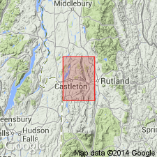
Type locality: on southwestern slope of Boardman Hill in Clarendon about 1.25 mi S. 50 deg. W. on top of hill, Rutland Co., west-central VT. Formation crops out in band that extends from northern to southern boundary of Castleton quadrangle from Pittsford Twp. through Proctor and Center Rutland to Clarendon Twp.
Source: Publication; US geologic names lexicon (USGS Bull. 1200, p. 408).
For more information, please contact Nancy Stamm, Geologic Names Committee Secretary.
Asterisk (*) indicates published by U.S. Geological Survey authors.
"No current usage" (†) implies that a name has been abandoned or has fallen into disuse. Former usage and, if known, replacement name given in parentheses ( ).
Slash (/) indicates name conflicts with nomenclatural guidelines (CSN, 1933; ACSN, 1961, 1970; NACSN, 1983, 2005, 2021). May be explained within brackets ([ ]).